You are here: Home > Network List > IU - Global Seismograph Network (GSN - IRIS/USGS) Stations List
> Station RSSD Black Hills, South Dakota, USA > Earthquake Result Viewer
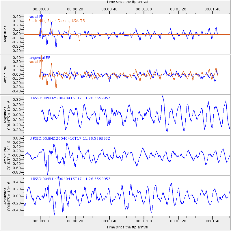
RSSD Black Hills, South Dakota, USA - Earthquake Result Viewer
*The percent match for this event was below the threshold and hence no stack was calculated.
| Earthquake location: |
South Of Tonga Islands |
| Earthquake latitude/longitude: |
-24.5/-175.9 |
| Earthquake time(UTC): |
2004/04/16 (107) 16:58:36 GMT |
| Earthquake Depth: |
10 km |
| Earthquake Magnitude: |
5.7 MB, 6.0 MS, 6.0 MW, 5.9 MW |
| Earthquake Catalog/Contributor: |
WHDF/NEIC |
|
| Network: |
IU Global Seismograph Network (GSN - IRIS/USGS) |
| Station: |
RSSD Black Hills, South Dakota, USA |
| Lat/Lon: |
44.12 N/104.04 W |
| Elevation: |
2060 m |
|
| Distance: |
94.7 deg |
| Az: |
43.366 deg |
| Baz: |
240.275 deg |
| Ray Param: |
$rayparam |
*The percent match for this event was below the threshold and hence was not used in the summary stack. |
|
| Radial Match: |
51.128304 % |
| Radial Bump: |
400 |
| Transverse Match: |
62.604282 % |
| Transverse Bump: |
400 |
| SOD ConfigId: |
590571 |
| Insert Time: |
2013-09-25 05:39:23.059 +0000 |
| GWidth: |
2.5 |
| Max Bumps: |
400 |
| Tol: |
0.001 |
|
Signal To Noise
| Channel | StoN | STA | LTA |
| IU:RSSD:00:BHZ:20040416T17:11:26.559995Z | 2.8895273 | 3.9266195E-7 | 1.3589141E-7 |
| IU:RSSD:00:BH1:20040416T17:11:26.559995Z | 0.7517376 | 1.2479654E-7 | 1.6601076E-7 |
| IU:RSSD:00:BH2:20040416T17:11:26.559995Z | 0.7792218 | 9.081618E-8 | 1.16547284E-7 |
| Arrivals |
| Ps | |
| PpPs | |
| PsPs/PpSs | |


