You are here: Home > Network List > IU - Global Seismograph Network (GSN - IRIS/USGS) Stations List
> Station RSSD Black Hills, South Dakota, USA > Earthquake Result Viewer
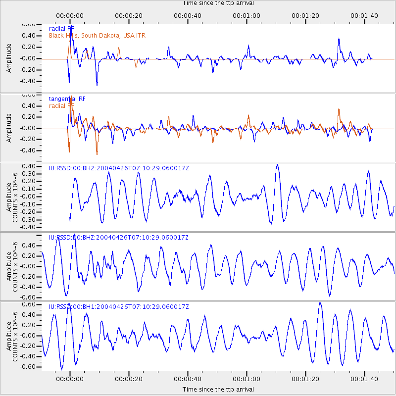
RSSD Black Hills, South Dakota, USA - Earthquake Result Viewer
*The percent match for this event was below the threshold and hence no stack was calculated.
| Earthquake location: |
Tonga Islands |
| Earthquake latitude/longitude: |
-21.0/-174.4 |
| Earthquake time(UTC): |
2004/04/26 (117) 06:57:55 GMT |
| Earthquake Depth: |
10 km |
| Earthquake Magnitude: |
5.5 MB, 5.5 MS, 5.8 MW |
| Earthquake Catalog/Contributor: |
NEIC PDE/NEIC PDE-M |
|
| Network: |
IU Global Seismograph Network (GSN - IRIS/USGS) |
| Station: |
RSSD Black Hills, South Dakota, USA |
| Lat/Lon: |
44.12 N/104.04 W |
| Elevation: |
2060 m |
|
| Distance: |
91.2 deg |
| Az: |
42.736 deg |
| Baz: |
241.671 deg |
| Ray Param: |
$rayparam |
*The percent match for this event was below the threshold and hence was not used in the summary stack. |
|
| Radial Match: |
77.29062 % |
| Radial Bump: |
400 |
| Transverse Match: |
54.280293 % |
| Transverse Bump: |
400 |
| SOD ConfigId: |
590571 |
| Insert Time: |
2013-09-25 05:46:59.467 +0000 |
| GWidth: |
2.5 |
| Max Bumps: |
400 |
| Tol: |
0.001 |
|
Signal To Noise
| Channel | StoN | STA | LTA |
| IU:RSSD:00:BHZ:20040426T07:10:29.060017Z | 2.0235388 | 3.306055E-7 | 1.6337987E-7 |
| IU:RSSD:00:BH1:20040426T07:10:29.060017Z | 1.5933845 | 3.9026096E-7 | 2.449258E-7 |
| IU:RSSD:00:BH2:20040426T07:10:29.060017Z | 0.53643394 | 9.907731E-8 | 1.8469619E-7 |
| Arrivals |
| Ps | |
| PpPs | |
| PsPs/PpSs | |


