You are here: Home > Network List > IU - Global Seismograph Network (GSN - IRIS/USGS) Stations List
> Station RSSD Black Hills, South Dakota, USA > Earthquake Result Viewer
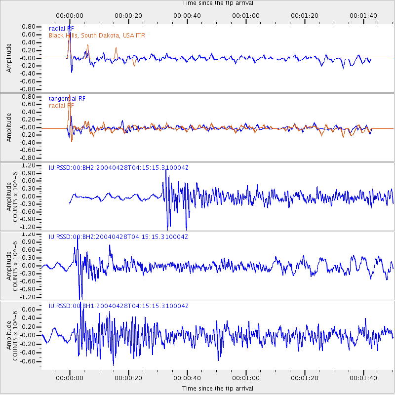
RSSD Black Hills, South Dakota, USA - Earthquake Result Viewer
*The percent match for this event was below the threshold and hence no stack was calculated.
| Earthquake location: |
Near Coast Of Nicaragua |
| Earthquake latitude/longitude: |
12.2/-87.4 |
| Earthquake time(UTC): |
2004/04/28 (119) 04:08:59 GMT |
| Earthquake Depth: |
62 km |
| Earthquake Magnitude: |
5.2 MB, 5.6 MW, 5.5 MW |
| Earthquake Catalog/Contributor: |
WHDF/NEIC |
|
| Network: |
IU Global Seismograph Network (GSN - IRIS/USGS) |
| Station: |
RSSD Black Hills, South Dakota, USA |
| Lat/Lon: |
44.12 N/104.04 W |
| Elevation: |
2060 m |
|
| Distance: |
34.9 deg |
| Az: |
338.917 deg |
| Baz: |
150.764 deg |
| Ray Param: |
$rayparam |
*The percent match for this event was below the threshold and hence was not used in the summary stack. |
|
| Radial Match: |
69.305275 % |
| Radial Bump: |
400 |
| Transverse Match: |
42.155872 % |
| Transverse Bump: |
400 |
| SOD ConfigId: |
590571 |
| Insert Time: |
2013-09-25 05:47:56.071 +0000 |
| GWidth: |
2.5 |
| Max Bumps: |
400 |
| Tol: |
0.001 |
|
Signal To Noise
| Channel | StoN | STA | LTA |
| IU:RSSD:00:BHZ:20040428T04:15:15.310004Z | 7.3014183 | 4.943399E-7 | 6.770463E-8 |
| IU:RSSD:00:BH1:20040428T04:15:15.310004Z | 3.5412824 | 2.6224552E-7 | 7.405383E-8 |
| IU:RSSD:00:BH2:20040428T04:15:15.310004Z | 6.7103624 | 4.9930696E-7 | 7.440834E-8 |
| Arrivals |
| Ps | |
| PpPs | |
| PsPs/PpSs | |


