You are here: Home > Network List > TA - USArray Transportable Network (new EarthScope stations) Stations List
> Station O48A Farmland, IN, USA > Earthquake Result Viewer
O48A Farmland, IN, USA - Earthquake Result Viewer
| Earthquake location: |
Southern Alaska |
| Earthquake latitude/longitude: |
62.0/-151.8 |
| Earthquake time(UTC): |
2014/09/25 (268) 17:51:17 GMT |
| Earthquake Depth: |
103 km |
| Earthquake Magnitude: |
6.2 ML, 6.1 MI, 6.2 MWW, 6.3 MWR, 6.3 MWB, 6.3 MWC |
| Earthquake Catalog/Contributor: |
NEIC PDE/NEIC COMCAT |
|
| Network: |
TA USArray Transportable Network (new EarthScope stations) |
| Station: |
O48A Farmland, IN, USA |
| Lat/Lon: |
40.26 N/85.16 W |
| Elevation: |
300 m |
|
| Distance: |
44.7 deg |
| Az: |
87.007 deg |
| Baz: |
321.918 deg |
| Ray Param: |
0.07139722 |
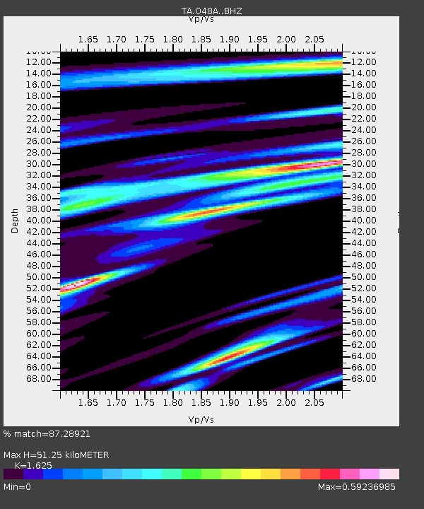
| Estimated Moho Depth: |
51.25 km |
| Estimated Crust Vp/Vs: |
1.62 |
| Assumed Crust Vp: |
6.498 km/s |
| Estimated Crust Vs: |
3.998 km/s |
| Estimated Crust Poisson's Ratio: |
0.20 |
|
| Radial Match: |
87.28921 % |
| Radial Bump: |
360 |
| Transverse Match: |
65.548996 % |
| Transverse Bump: |
400 |
| SOD ConfigId: |
3390531 |
| Insert Time: |
2019-04-14 05:34:44.157 +0000 |
| GWidth: |
2.5 |
| Max Bumps: |
400 |
| Tol: |
0.001 |
|
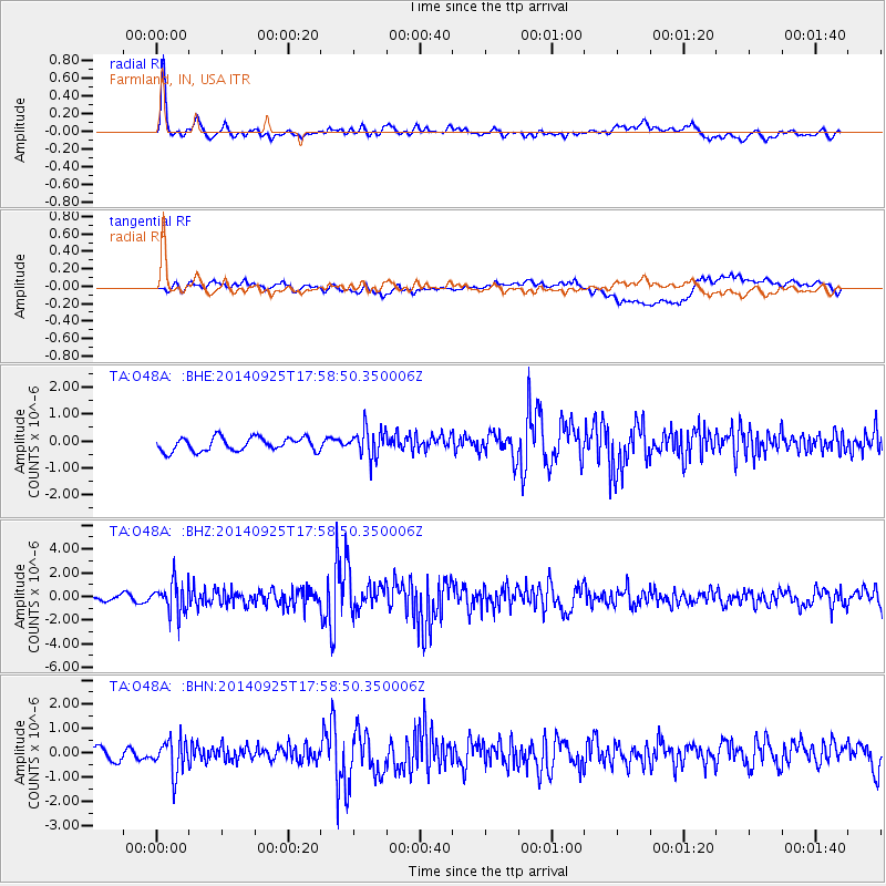
Signal To Noise
| Channel | StoN | STA | LTA |
| TA:O48A: :BHZ:20140925T17:58:50.350006Z | 7.1094313 | 1.3117532E-6 | 1.8450888E-7 |
| TA:O48A: :BHN:20140925T17:58:50.350006Z | 3.131343 | 6.7538366E-7 | 2.1568499E-7 |
| TA:O48A: :BHE:20140925T17:58:50.350006Z | 1.9859776 | 4.8813786E-7 | 2.4579222E-7 |
| Arrivals |
| Ps | 5.3 SECOND |
| PpPs | 19 SECOND |
| PsPs/PpSs | 25 SECOND |


