You are here: Home > Network List > TA - USArray Transportable Network (new EarthScope stations) Stations List
> Station V61A Roper, NC, USA > Earthquake Result Viewer
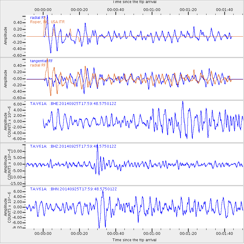
V61A Roper, NC, USA - Earthquake Result Viewer
*The percent match for this event was below the threshold and hence no stack was calculated.
| Earthquake location: |
Southern Alaska |
| Earthquake latitude/longitude: |
62.0/-151.8 |
| Earthquake time(UTC): |
2014/09/25 (268) 17:51:17 GMT |
| Earthquake Depth: |
103 km |
| Earthquake Magnitude: |
6.2 ML, 6.1 MI, 6.2 MWW, 6.3 MWR, 6.3 MWB, 6.3 MWC |
| Earthquake Catalog/Contributor: |
NEIC PDE/NEIC COMCAT |
|
| Network: |
TA USArray Transportable Network (new EarthScope stations) |
| Station: |
V61A Roper, NC, USA |
| Lat/Lon: |
35.79 N/76.58 W |
| Elevation: |
4.0 m |
|
| Distance: |
52.3 deg |
| Az: |
83.305 deg |
| Baz: |
324.732 deg |
| Ray Param: |
$rayparam |
*The percent match for this event was below the threshold and hence was not used in the summary stack. |
|
| Radial Match: |
70.36701 % |
| Radial Bump: |
400 |
| Transverse Match: |
71.46902 % |
| Transverse Bump: |
380 |
| SOD ConfigId: |
3390531 |
| Insert Time: |
2019-04-14 05:34:53.700 +0000 |
| GWidth: |
2.5 |
| Max Bumps: |
400 |
| Tol: |
0.001 |
|
Signal To Noise
| Channel | StoN | STA | LTA |
| TA:V61A: :BHZ:20140925T17:59:48.575012Z | 1.7153869 | 1.4392093E-6 | 8.389999E-7 |
| TA:V61A: :BHN:20140925T17:59:48.575012Z | 1.0264734 | 1.4523939E-6 | 1.4149357E-6 |
| TA:V61A: :BHE:20140925T17:59:48.575012Z | 0.6050305 | 1.0315692E-6 | 1.7049873E-6 |
| Arrivals |
| Ps | |
| PpPs | |
| PsPs/PpSs | |


