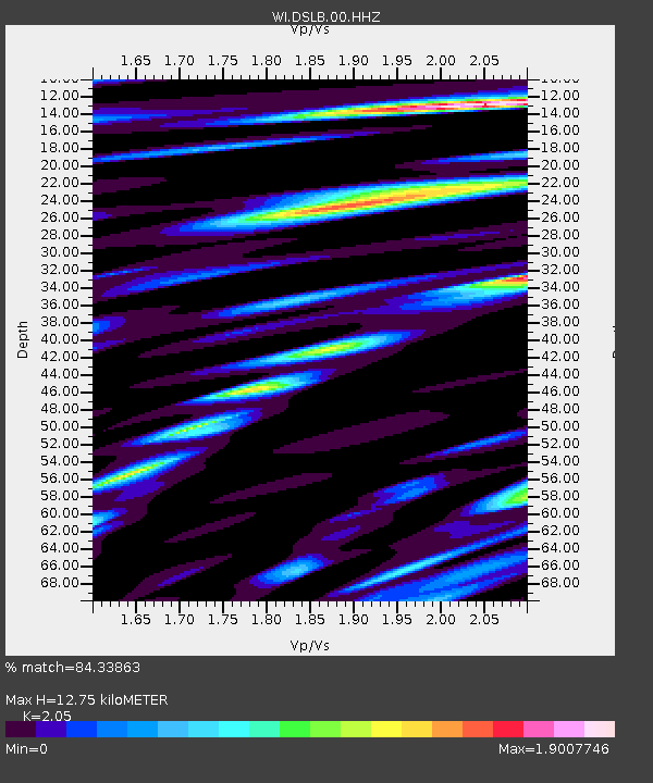
DSLB Salisbury, Dominica - Earthquake Result Viewer

Earthquake location: Southern Alaska
Earthquake latitude/longitude: 62.0/-151.8
Earthquake time(UTC): 2014/09/25 (268) 17:51:17 GMT
Earthquake Depth: 103 km
Earthquake Magnitude: 6.2 ML, 6.1 MI, 6.2 MWW, 6.3 MWR, 6.3 MWB, 6.3 MWC
Earthquake Catalog/Contributor: NEIC PDE/NEIC COMCAT
Network: WI West Indies IPGP Network
Station: DSLB Salisbury, Dominica
Lat/Lon: 15.44 N/61.42 W
Elevation: 324 m
Distance: 76.7 deg
Az: 82.297 deg
Baz: 330.942 deg
Ray Param: 0.050588377
Estimated Moho Depth: 12.75 km
Estimated Crust Vp/Vs: 2.05
Assumed Crust Vp: 5.88 km/s
Estimated Crust Vs: 2.868 km/s
Estimated Crust Poisson's Ratio: 0.34
Radial Match: 84.33863 %
Radial Bump: 400
Transverse Match: 72.5123 %
Transverse Bump: 400
SOD ConfigId: 3390531
Insert Time: 2019-04-14 05:35:40.273 +0000
GWidth: 2.5
Max Bumps: 400
Tol: 0.001

Signal To Noise

ChannelStoNSTALTA
WI:DSLB:00:HHZ:20140925T18:02:26.619995Z2.62313777.454512E-72.8418302E-7
WI:DSLB:00:HHN:20140925T18:02:26.619995Z1.73648885.0056974E-72.8826545E-7
WI:DSLB:00:HHE:20140925T18:02:26.619995Z1.88612454.912185E-72.60438E-7
Arrivals
Ps2.3 SECOND
PpPs6.5 SECOND
PsPs/PpSs8.8 SECOND