You are here: Home > Network List > IU - Global Seismograph Network (GSN - IRIS/USGS) Stations List
> Station RSSD Black Hills, South Dakota, USA > Earthquake Result Viewer
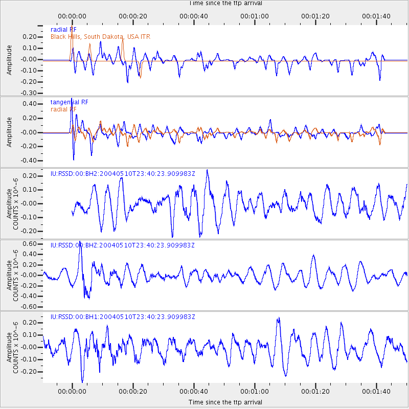
RSSD Black Hills, South Dakota, USA - Earthquake Result Viewer
*The percent match for this event was below the threshold and hence no stack was calculated.
| Earthquake location: |
Qinghai, China |
| Earthquake latitude/longitude: |
37.5/96.6 |
| Earthquake time(UTC): |
2004/05/10 (131) 23:27:25 GMT |
| Earthquake Depth: |
10 km |
| Earthquake Magnitude: |
5.6 MW, 5.5 MW |
| Earthquake Catalog/Contributor: |
NEIC PDE/NEIC PDE-M |
|
| Network: |
IU Global Seismograph Network (GSN - IRIS/USGS) |
| Station: |
RSSD Black Hills, South Dakota, USA |
| Lat/Lon: |
44.12 N/104.04 W |
| Elevation: |
2060 m |
|
| Distance: |
96.6 deg |
| Az: |
14.809 deg |
| Baz: |
343.602 deg |
| Ray Param: |
$rayparam |
*The percent match for this event was below the threshold and hence was not used in the summary stack. |
|
| Radial Match: |
46.23621 % |
| Radial Bump: |
390 |
| Transverse Match: |
69.880486 % |
| Transverse Bump: |
400 |
| SOD ConfigId: |
590571 |
| Insert Time: |
2013-09-25 05:56:22.296 +0000 |
| GWidth: |
2.5 |
| Max Bumps: |
400 |
| Tol: |
0.001 |
|
Signal To Noise
| Channel | StoN | STA | LTA |
| IU:RSSD:00:BHZ:20040510T23:40:23.909983Z | 4.9051948 | 2.7974372E-7 | 5.7030093E-8 |
| IU:RSSD:00:BH1:20040510T23:40:23.909983Z | 2.1807134 | 1.2830391E-7 | 5.8835752E-8 |
| IU:RSSD:00:BH2:20040510T23:40:23.909983Z | 1.0525899 | 9.0704376E-8 | 8.617257E-8 |
| Arrivals |
| Ps | |
| PpPs | |
| PsPs/PpSs | |


