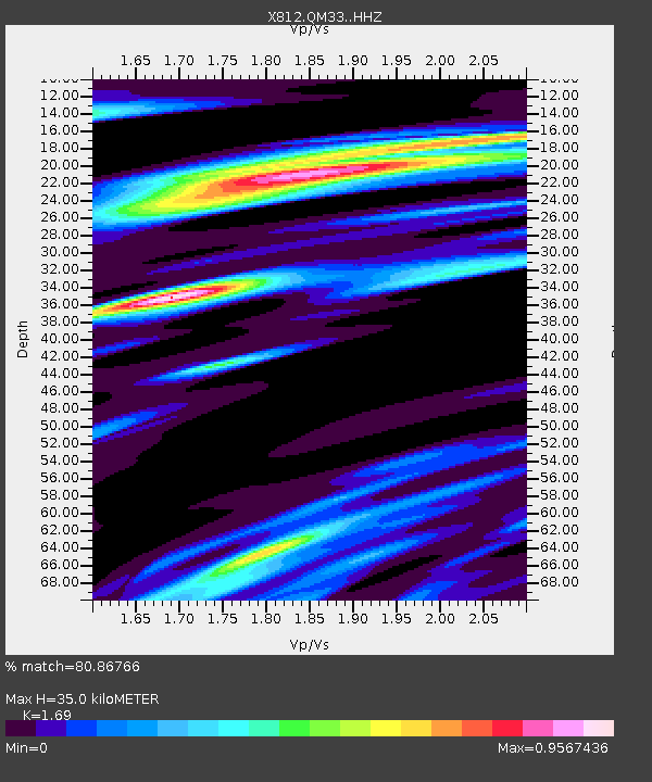
QM33 Maine - Earthquake Result Viewer

Earthquake location: Southern Alaska
Earthquake latitude/longitude: 62.0/-151.8
Earthquake time(UTC): 2014/09/25 (268) 17:51:17 GMT
Earthquake Depth: 103 km
Earthquake Magnitude: 6.2 ML, 6.1 MI, 6.2 MWW, 6.3 MWR, 6.3 MWB, 6.3 MWC
Earthquake Catalog/Contributor: NEIC PDE/NEIC COMCAT
Network: X8 Deep Structure of Three Continental Sutures in Eastern North America
Station: QM33 Maine
Lat/Lon: 47.21 N/69.40 W
Elevation: 0.0 m
Distance: 46.6 deg
Az: 68.5 deg
Baz: 319.827 deg
Ray Param: 0.07020837
Estimated Moho Depth: 35.0 km
Estimated Crust Vp/Vs: 1.69
Assumed Crust Vp: 6.419 km/s
Estimated Crust Vs: 3.798 km/s
Estimated Crust Poisson's Ratio: 0.23
Radial Match: 80.86766 %
Radial Bump: 400
Transverse Match: 42.59805 %
Transverse Bump: 400
SOD ConfigId: 3390531
Insert Time: 2019-04-14 05:35:53.145 +0000
GWidth: 2.5
Max Bumps: 400
Tol: 0.001

Signal To Noise

ChannelStoNSTALTA
X8:QM33: :HHZ:20140925T17:59:04.88501Z4.9552031.9417853E-63.9186799E-7
X8:QM33: :HHN:20140925T17:59:04.88501Z1.09252028.953182E-78.19498E-7
X8:QM33: :HHE:20140925T17:59:04.88501Z0.87101575.837125E-76.701515E-7
Arrivals
Ps4.0 SECOND
PpPs14 SECOND
PsPs/PpSs18 SECOND