You are here: Home > Network List > IU - Global Seismograph Network (GSN - IRIS/USGS) Stations List
> Station RSSD Black Hills, South Dakota, USA > Earthquake Result Viewer
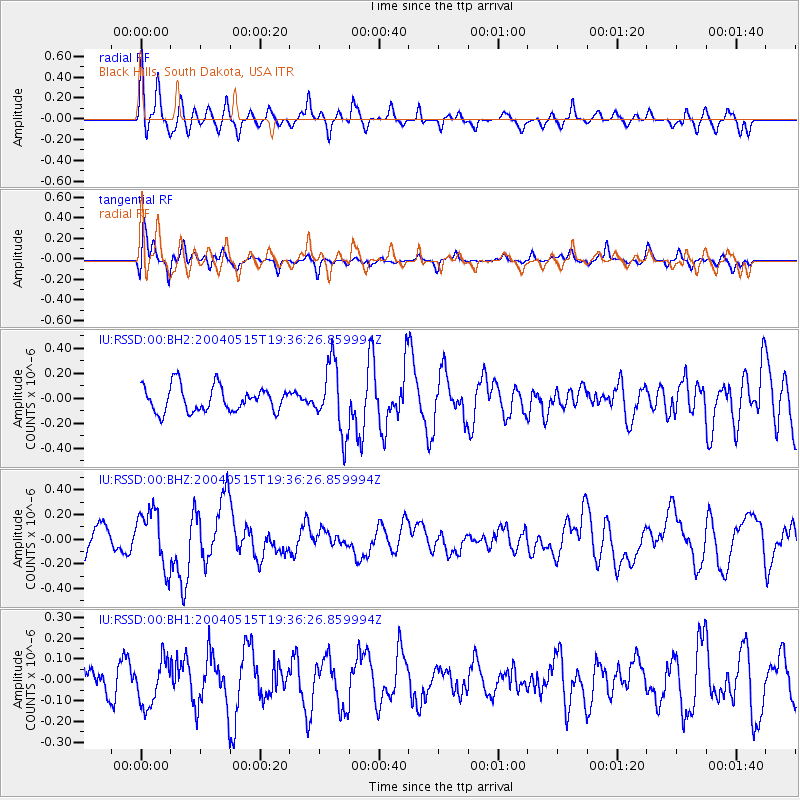
RSSD Black Hills, South Dakota, USA - Earthquake Result Viewer
*The percent match for this event was below the threshold and hence no stack was calculated.
| Earthquake location: |
Near Coast Of Chiapas, Mexico |
| Earthquake latitude/longitude: |
14.2/-93.1 |
| Earthquake time(UTC): |
2004/05/15 (136) 19:30:37 GMT |
| Earthquake Depth: |
10 km |
| Earthquake Magnitude: |
4.9 MB, 5.1 MS, 5.5 MW, 5.0 MD |
| Earthquake Catalog/Contributor: |
WHDF/NEIC |
|
| Network: |
IU Global Seismograph Network (GSN - IRIS/USGS) |
| Station: |
RSSD Black Hills, South Dakota, USA |
| Lat/Lon: |
44.12 N/104.04 W |
| Elevation: |
2060 m |
|
| Distance: |
31.3 deg |
| Az: |
344.711 deg |
| Baz: |
159.199 deg |
| Ray Param: |
$rayparam |
*The percent match for this event was below the threshold and hence was not used in the summary stack. |
|
| Radial Match: |
62.373905 % |
| Radial Bump: |
400 |
| Transverse Match: |
68.94292 % |
| Transverse Bump: |
400 |
| SOD ConfigId: |
590571 |
| Insert Time: |
2013-09-25 05:58:48.188 +0000 |
| GWidth: |
2.5 |
| Max Bumps: |
400 |
| Tol: |
0.001 |
|
Signal To Noise
| Channel | StoN | STA | LTA |
| IU:RSSD:00:BHZ:20040515T19:36:26.859994Z | 1.5288047 | 2.3135216E-7 | 1.5132879E-7 |
| IU:RSSD:00:BH1:20040515T19:36:26.859994Z | 0.755314 | 1.0935333E-7 | 1.4477864E-7 |
| IU:RSSD:00:BH2:20040515T19:36:26.859994Z | 2.7454054 | 2.7431082E-7 | 9.991632E-8 |
| Arrivals |
| Ps | |
| PpPs | |
| PsPs/PpSs | |


