You are here: Home > Network List > IU - Global Seismograph Network (GSN - IRIS/USGS) Stations List
> Station RSSD Black Hills, South Dakota, USA > Earthquake Result Viewer
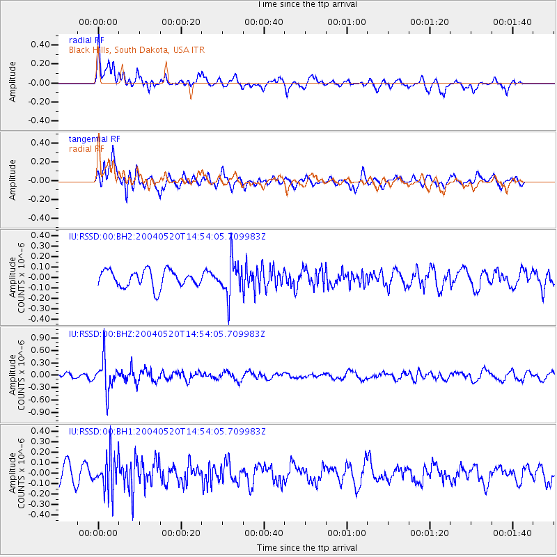
RSSD Black Hills, South Dakota, USA - Earthquake Result Viewer
*The percent match for this event was below the threshold and hence no stack was calculated.
| Earthquake location: |
Eastern Sea Of Japan |
| Earthquake latitude/longitude: |
43.1/136.4 |
| Earthquake time(UTC): |
2004/05/20 (141) 14:43:14 GMT |
| Earthquake Depth: |
313 km |
| Earthquake Magnitude: |
5.6 MW |
| Earthquake Catalog/Contributor: |
NEIC PDE/NEIC PDE-M |
|
| Network: |
IU Global Seismograph Network (GSN - IRIS/USGS) |
| Station: |
RSSD Black Hills, South Dakota, USA |
| Lat/Lon: |
44.12 N/104.04 W |
| Elevation: |
2060 m |
|
| Distance: |
77.7 deg |
| Az: |
39.879 deg |
| Baz: |
319.323 deg |
| Ray Param: |
$rayparam |
*The percent match for this event was below the threshold and hence was not used in the summary stack. |
|
| Radial Match: |
72.54552 % |
| Radial Bump: |
400 |
| Transverse Match: |
66.52746 % |
| Transverse Bump: |
400 |
| SOD ConfigId: |
590571 |
| Insert Time: |
2013-09-25 06:01:56.624 +0000 |
| GWidth: |
2.5 |
| Max Bumps: |
400 |
| Tol: |
0.001 |
|
Signal To Noise
| Channel | StoN | STA | LTA |
| IU:RSSD:00:BHZ:20040520T14:54:05.709983Z | 3.8948555 | 3.904501E-7 | 1.00247654E-7 |
| IU:RSSD:00:BH1:20040520T14:54:05.709983Z | 2.2209113 | 1.7832382E-7 | 8.029309E-8 |
| IU:RSSD:00:BH2:20040520T14:54:05.709983Z | 2.190072 | 1.7553913E-7 | 8.015222E-8 |
| Arrivals |
| Ps | |
| PpPs | |
| PsPs/PpSs | |


