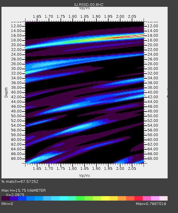
RSSD Black Hills, South Dakota, USA - Earthquake Result Viewer

Earthquake location: Off East Coast Of Honshu, Japan
Earthquake latitude/longitude: 34.3/141.4
Earthquake time(UTC): 2004/05/29 (150) 20:56:09 GMT
Earthquake Depth: 16 km
Earthquake Magnitude: 5.6 MB, 6.6 MS, 6.5 MW, 6.3 MW
Earthquake Catalog/Contributor: WHDF/NEIC
Network: IU Global Seismograph Network (GSN - IRIS/USGS)
Station: RSSD Black Hills, South Dakota, USA
Lat/Lon: 44.12 N/104.04 W
Elevation: 2060 m
Distance: 81.9 deg
Az: 41.426 deg
Baz: 310.45 deg
Ray Param: 0.047243915
Estimated Moho Depth: 15.75 km
Estimated Crust Vp/Vs: 2.10
Assumed Crust Vp: 6.242 km/s
Estimated Crust Vs: 2.976 km/s
Estimated Crust Poisson's Ratio: 0.35
Radial Match: 97.57252 %
Radial Bump: 277
Transverse Match: 88.2868 %
Transverse Bump: 400
SOD ConfigId: 590571
Insert Time: 2013-09-25 06:05:06.772 +0000
GWidth: 2.5
Max Bumps: 400
Tol: 0.001

Signal To Noise

ChannelStoNSTALTA
IU:RSSD:00:BHZ:20040529T21:07:56.810022Z7.18796544.3997974E-76.1210606E-8
IU:RSSD:00:BH1:20040529T21:07:56.810022Z2.301541.1077421E-74.8130474E-8
IU:RSSD:00:BH2:20040529T21:07:56.810022Z1.52767591.2972993E-78.49198E-8
Arrivals
Ps2.8 SECOND
PpPs7.7 SECOND
PsPs/PpSs10 SECOND