You are here: Home > Network List > IU - Global Seismograph Network (GSN - IRIS/USGS) Stations List
> Station RSSD Black Hills, South Dakota, USA > Earthquake Result Viewer
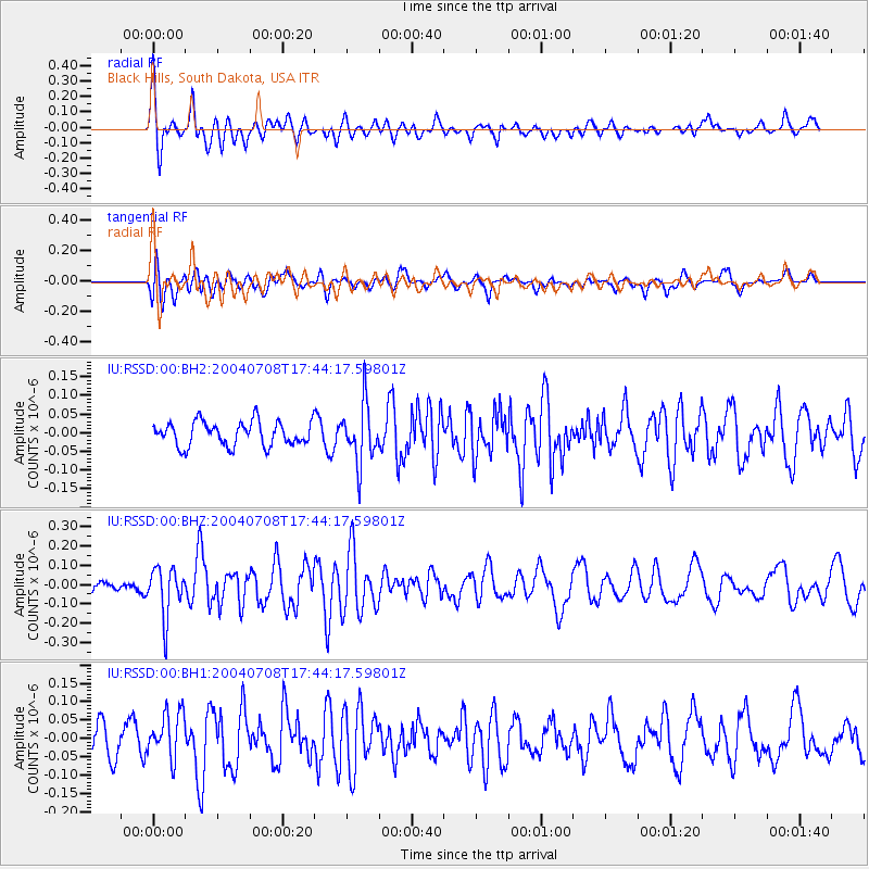
RSSD Black Hills, South Dakota, USA - Earthquake Result Viewer
*The percent match for this event was below the threshold and hence no stack was calculated.
| Earthquake location: |
Southern East Pacific Rise |
| Earthquake latitude/longitude: |
-25.1/-116.2 |
| Earthquake time(UTC): |
2004/07/08 (190) 17:33:38 GMT |
| Earthquake Depth: |
10 km |
| Earthquake Magnitude: |
5.7 MW, 5.6 MW |
| Earthquake Catalog/Contributor: |
NEIC PDE/NEIC PDE-M |
|
| Network: |
IU Global Seismograph Network (GSN - IRIS/USGS) |
| Station: |
RSSD Black Hills, South Dakota, USA |
| Lat/Lon: |
44.12 N/104.04 W |
| Elevation: |
2060 m |
|
| Distance: |
69.8 deg |
| Az: |
9.283 deg |
| Baz: |
191.719 deg |
| Ray Param: |
$rayparam |
*The percent match for this event was below the threshold and hence was not used in the summary stack. |
|
| Radial Match: |
70.72268 % |
| Radial Bump: |
400 |
| Transverse Match: |
56.55039 % |
| Transverse Bump: |
400 |
| SOD ConfigId: |
590571 |
| Insert Time: |
2013-09-25 06:25:00.523 +0000 |
| GWidth: |
2.5 |
| Max Bumps: |
400 |
| Tol: |
0.001 |
|
Signal To Noise
| Channel | StoN | STA | LTA |
| IU:RSSD:00:BHZ:20040708T17:44:17.59801Z | 2.1049545 | 1.2642505E-7 | 6.00607E-8 |
| IU:RSSD:00:BH1:20040708T17:44:17.59801Z | 1.2515339 | 6.338796E-8 | 5.0648215E-8 |
| IU:RSSD:00:BH2:20040708T17:44:17.59801Z | 2.4464443 | 7.9243435E-8 | 3.239127E-8 |
| Arrivals |
| Ps | |
| PpPs | |
| PsPs/PpSs | |


