You are here: Home > Network List > IU - Global Seismograph Network (GSN - IRIS/USGS) Stations List
> Station POHA Pohakuloa, Hawaii, USA > Earthquake Result Viewer
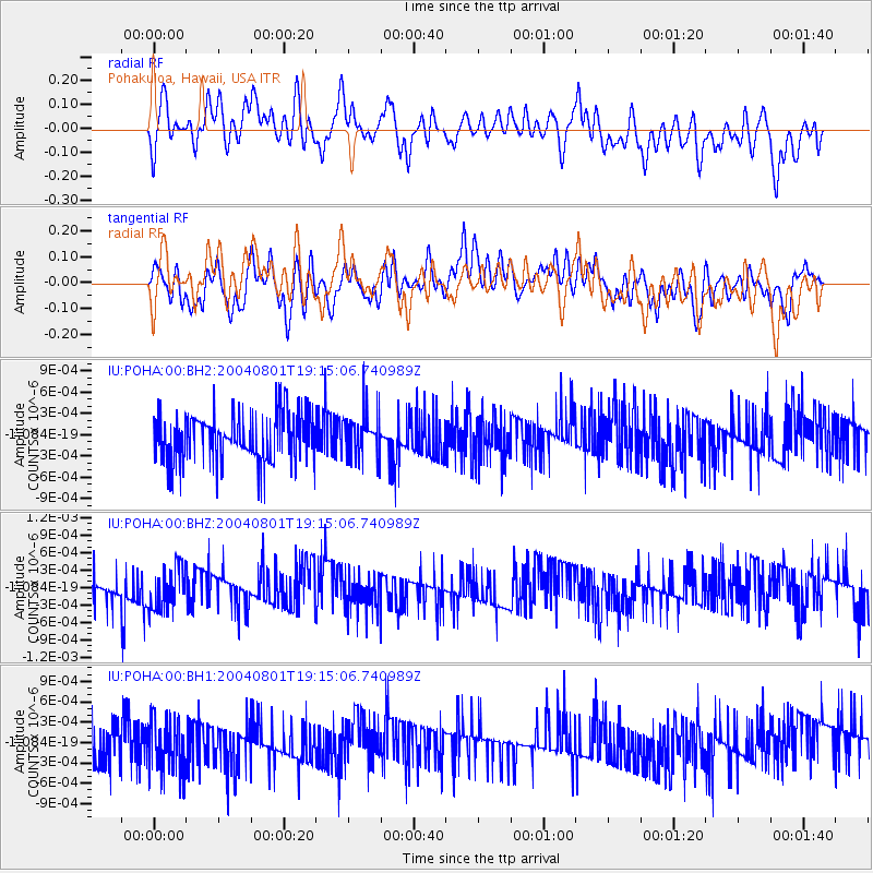
POHA Pohakuloa, Hawaii, USA - Earthquake Result Viewer
*The percent match for this event was below the threshold and hence no stack was calculated.
| Earthquake location: |
Pacific-Antarctic Ridge |
| Earthquake latitude/longitude: |
-63.6/-166.7 |
| Earthquake time(UTC): |
2004/08/01 (214) 19:03:10 GMT |
| Earthquake Depth: |
10 km |
| Earthquake Magnitude: |
6.0 MW, 6.0 MW, 6.0 MS |
| Earthquake Catalog/Contributor: |
NEIC PDE/NEIC PDE-M |
|
| Network: |
IU Global Seismograph Network (GSN - IRIS/USGS) |
| Station: |
POHA Pohakuloa, Hawaii, USA |
| Lat/Lon: |
19.76 N/155.53 W |
| Elevation: |
1967 m |
|
| Distance: |
83.5 deg |
| Az: |
10.547 deg |
| Baz: |
184.991 deg |
| Ray Param: |
$rayparam |
*The percent match for this event was below the threshold and hence was not used in the summary stack. |
|
| Radial Match: |
51.095848 % |
| Radial Bump: |
400 |
| Transverse Match: |
51.86408 % |
| Transverse Bump: |
400 |
| SOD ConfigId: |
590571 |
| Insert Time: |
2013-09-25 06:39:08.375 +0000 |
| GWidth: |
2.5 |
| Max Bumps: |
400 |
| Tol: |
0.001 |
|
Signal To Noise
| Channel | StoN | STA | LTA |
| IU:POHA:00:BHZ:20040801T19:15:06.740989Z | 1.1482229 | 3.7890116E-10 | 3.299892E-10 |
| IU:POHA:00:BH1:20040801T19:15:06.740989Z | 1.4934105 | 4.1928494E-10 | 2.8075667E-10 |
| IU:POHA:00:BH2:20040801T19:15:06.740989Z | 0.827885 | 2.8038422E-10 | 3.386753E-10 |
| Arrivals |
| Ps | |
| PpPs | |
| PsPs/PpSs | |


