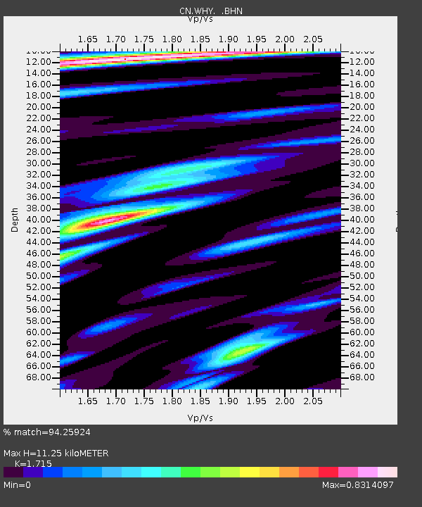
WHY Whitehorse, YT - Earthquake Result Viewer
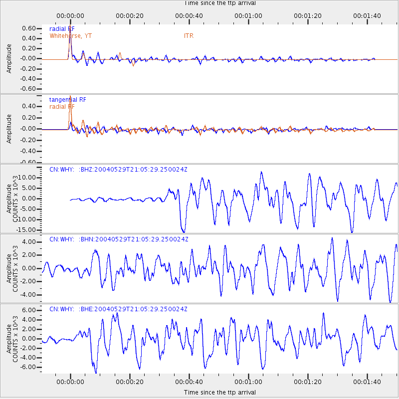
Earthquake location: Off East Coast Of Honshu, Japan
Earthquake latitude/longitude: 34.3/141.4
Earthquake time(UTC): 2004/05/29 (150) 20:56:09 GMT
Earthquake Depth: 16 km
Earthquake Magnitude: 5.6 MB, 6.6 MS, 6.5 MW, 6.3 MW
Earthquake Catalog/Contributor: WHDF/NEIC
Network: CN Canadian National Seismograph Network
Station: WHY Whitehorse, YT
Lat/Lon: 60.66 N/134.88 W
Elevation: 1292 m
Distance: 57.8 deg
Az: 35.328 deg
Baz: 283.454 deg
Ray Param: 0.06321894
Estimated Moho Depth: 11.25 km
Estimated Crust Vp/Vs: 1.72
Assumed Crust Vp: 6.419 km/s
Estimated Crust Vs: 3.743 km/s
Estimated Crust Poisson's Ratio: 0.24
Radial Match: 94.25924 %
Radial Bump: 386
Transverse Match: 86.36526 %
Transverse Bump: 400
SOD ConfigId: 2459
Insert Time: 2010-02-27 07:47:12.367 +0000
GWidth: 2.5
Max Bumps: 400
Tol: 0.001

Signal To Noise

ChannelStoNSTALTA
CN:WHY: :BHN:20040529T21:05:29.250024Z1.2753431585.15875458.82462
CN:WHY: :BHE:20040529T21:05:29.250024Z1.6859046940.60034557.9202
CN:WHY: :BHZ:20040529T21:05:29.250024Z4.84579942349.0215484.75415
Arrivals
Ps1.3 SECOND
PpPs4.5 SECOND
PsPs/PpSs5.8 SECOND