You are here: Home > Network List > IU - Global Seismograph Network (GSN - IRIS/USGS) Stations List
> Station RSSD Black Hills, South Dakota, USA > Earthquake Result Viewer
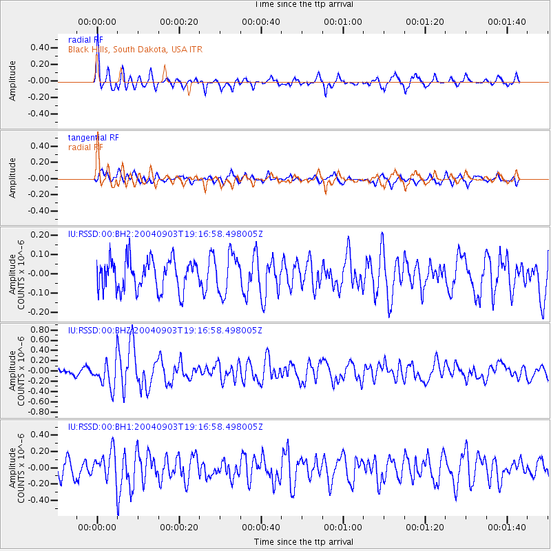
RSSD Black Hills, South Dakota, USA - Earthquake Result Viewer
*The percent match for this event was below the threshold and hence no stack was calculated.
| Earthquake location: |
Tonga Islands |
| Earthquake latitude/longitude: |
-15.3/-173.3 |
| Earthquake time(UTC): |
2004/09/03 (247) 19:04:47 GMT |
| Earthquake Depth: |
10 km |
| Earthquake Magnitude: |
5.5 MB, 5.8 MS, 6.2 MW, 6.0 MW |
| Earthquake Catalog/Contributor: |
WHDF/NEIC |
|
| Network: |
IU Global Seismograph Network (GSN - IRIS/USGS) |
| Station: |
RSSD Black Hills, South Dakota, USA |
| Lat/Lon: |
44.12 N/104.04 W |
| Elevation: |
2060 m |
|
| Distance: |
86.3 deg |
| Az: |
42.464 deg |
| Baz: |
244.796 deg |
| Ray Param: |
$rayparam |
*The percent match for this event was below the threshold and hence was not used in the summary stack. |
|
| Radial Match: |
69.07554 % |
| Radial Bump: |
400 |
| Transverse Match: |
57.658585 % |
| Transverse Bump: |
400 |
| SOD ConfigId: |
590571 |
| Insert Time: |
2013-09-25 06:55:58.338 +0000 |
| GWidth: |
2.5 |
| Max Bumps: |
400 |
| Tol: |
0.001 |
|
Signal To Noise
| Channel | StoN | STA | LTA |
| IU:RSSD:00:BHZ:20040903T19:16:58.498005Z | 2.9902604 | 2.7797168E-7 | 9.295902E-8 |
| IU:RSSD:00:BH1:20040903T19:16:58.498005Z | 1.706888 | 1.8332481E-7 | 1.07402954E-7 |
| IU:RSSD:00:BH2:20040903T19:16:58.498005Z | 1.2957376 | 1.0234862E-7 | 7.89887E-8 |
| Arrivals |
| Ps | |
| PpPs | |
| PsPs/PpSs | |


