You are here: Home > Network List > IU - Global Seismograph Network (GSN - IRIS/USGS) Stations List
> Station RSSD Black Hills, South Dakota, USA > Earthquake Result Viewer
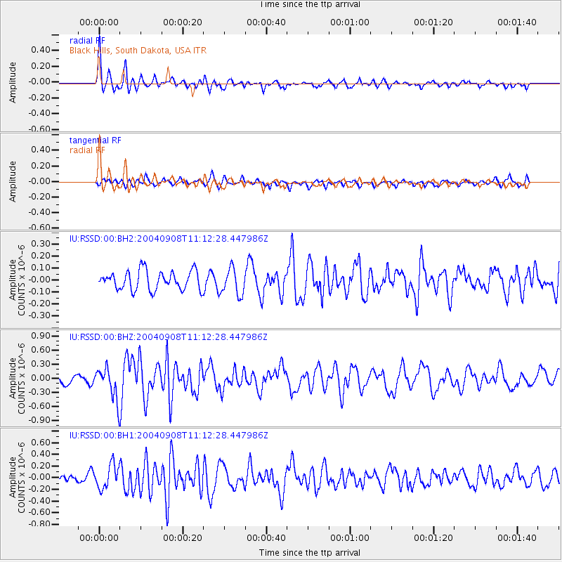
RSSD Black Hills, South Dakota, USA - Earthquake Result Viewer
*The percent match for this event was below the threshold and hence no stack was calculated.
| Earthquake location: |
Tonga Islands |
| Earthquake latitude/longitude: |
-15.2/-173.4 |
| Earthquake time(UTC): |
2004/09/08 (252) 11:00:18 GMT |
| Earthquake Depth: |
13 km |
| Earthquake Magnitude: |
5.6 MB, 5.6 MS, 5.9 MW, 5.8 MW |
| Earthquake Catalog/Contributor: |
WHDF/NEIC |
|
| Network: |
IU Global Seismograph Network (GSN - IRIS/USGS) |
| Station: |
RSSD Black Hills, South Dakota, USA |
| Lat/Lon: |
44.12 N/104.04 W |
| Elevation: |
2060 m |
|
| Distance: |
86.3 deg |
| Az: |
42.496 deg |
| Baz: |
244.928 deg |
| Ray Param: |
$rayparam |
*The percent match for this event was below the threshold and hence was not used in the summary stack. |
|
| Radial Match: |
73.15448 % |
| Radial Bump: |
351 |
| Transverse Match: |
56.17934 % |
| Transverse Bump: |
340 |
| SOD ConfigId: |
590571 |
| Insert Time: |
2013-09-25 07:05:46.625 +0000 |
| GWidth: |
2.5 |
| Max Bumps: |
400 |
| Tol: |
0.001 |
|
Signal To Noise
| Channel | StoN | STA | LTA |
| IU:RSSD:00:BHZ:20040908T11:12:28.447986Z | 2.940769 | 3.5350135E-7 | 1.2020712E-7 |
| IU:RSSD:00:BH1:20040908T11:12:28.447986Z | 1.962222 | 2.0997584E-7 | 1.0700922E-7 |
| IU:RSSD:00:BH2:20040908T11:12:28.447986Z | 1.4071981 | 1.1019318E-7 | 7.83068E-8 |
| Arrivals |
| Ps | |
| PpPs | |
| PsPs/PpSs | |


