You are here: Home > Network List > IU - Global Seismograph Network (GSN - IRIS/USGS) Stations List
> Station RSSD Black Hills, South Dakota, USA > Earthquake Result Viewer
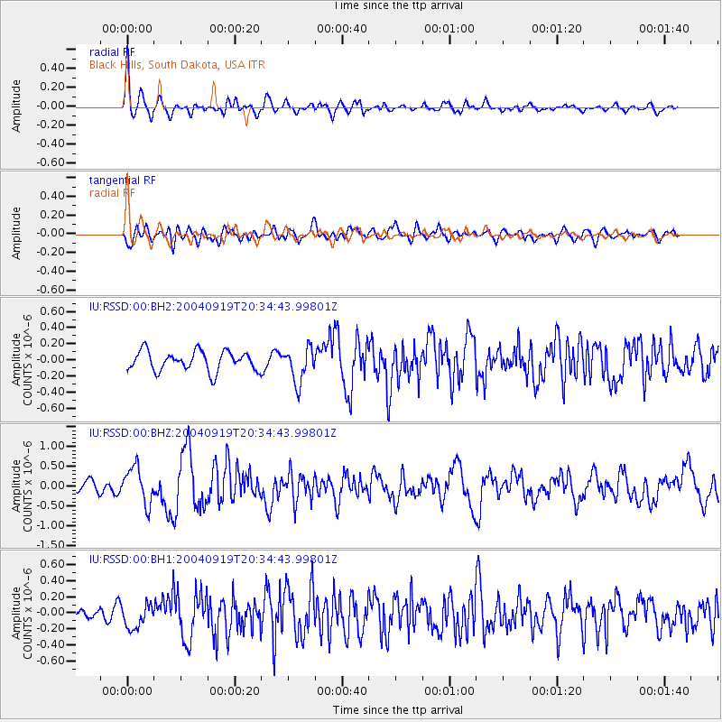
RSSD Black Hills, South Dakota, USA - Earthquake Result Viewer
*The percent match for this event was below the threshold and hence no stack was calculated.
| Earthquake location: |
Near Islands, Aleutian Islands |
| Earthquake latitude/longitude: |
52.2/174.0 |
| Earthquake time(UTC): |
2004/09/19 (263) 20:26:04 GMT |
| Earthquake Depth: |
25 km |
| Earthquake Magnitude: |
5.6 MB, 6.0 MS, 6.2 MW, 6.1 MW |
| Earthquake Catalog/Contributor: |
WHDF/NEIC |
|
| Network: |
IU Global Seismograph Network (GSN - IRIS/USGS) |
| Station: |
RSSD Black Hills, South Dakota, USA |
| Lat/Lon: |
44.12 N/104.04 W |
| Elevation: |
2060 m |
|
| Distance: |
52.5 deg |
| Az: |
64.031 deg |
| Baz: |
309.807 deg |
| Ray Param: |
$rayparam |
*The percent match for this event was below the threshold and hence was not used in the summary stack. |
|
| Radial Match: |
72.1162 % |
| Radial Bump: |
400 |
| Transverse Match: |
62.678825 % |
| Transverse Bump: |
400 |
| SOD ConfigId: |
590571 |
| Insert Time: |
2013-09-25 07:14:43.080 +0000 |
| GWidth: |
2.5 |
| Max Bumps: |
400 |
| Tol: |
0.001 |
|
Signal To Noise
| Channel | StoN | STA | LTA |
| IU:RSSD:00:BHZ:20040919T20:34:43.99801Z | 2.843759 | 4.6481512E-7 | 1.6345095E-7 |
| IU:RSSD:00:BH1:20040919T20:34:43.99801Z | 1.2112993 | 1.4854749E-7 | 1.2263483E-7 |
| IU:RSSD:00:BH2:20040919T20:34:43.99801Z | 1.7824748 | 2.16355E-7 | 1.21379E-7 |
| Arrivals |
| Ps | |
| PpPs | |
| PsPs/PpSs | |


