You are here: Home > Network List > IU - Global Seismograph Network (GSN - IRIS/USGS) Stations List
> Station RSSD Black Hills, South Dakota, USA > Earthquake Result Viewer
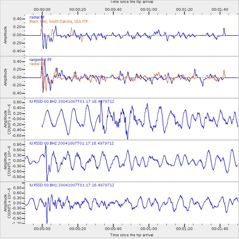
RSSD Black Hills, South Dakota, USA - Earthquake Result Viewer
*The percent match for this event was below the threshold and hence no stack was calculated.
| Earthquake location: |
Dodecanese Islands, Greece |
| Earthquake latitude/longitude: |
36.4/26.8 |
| Earthquake time(UTC): |
2004/10/07 (281) 01:05:12 GMT |
| Earthquake Depth: |
129 km |
| Earthquake Magnitude: |
5.7 MB, 5.5 MW |
| Earthquake Catalog/Contributor: |
NEIC PDE/NEIC PDE-M |
|
| Network: |
IU Global Seismograph Network (GSN - IRIS/USGS) |
| Station: |
RSSD Black Hills, South Dakota, USA |
| Lat/Lon: |
44.12 N/104.04 W |
| Elevation: |
2060 m |
|
| Distance: |
88.3 deg |
| Az: |
326.963 deg |
| Baz: |
37.625 deg |
| Ray Param: |
$rayparam |
*The percent match for this event was below the threshold and hence was not used in the summary stack. |
|
| Radial Match: |
50.721855 % |
| Radial Bump: |
400 |
| Transverse Match: |
71.51359 % |
| Transverse Bump: |
400 |
| SOD ConfigId: |
590571 |
| Insert Time: |
2013-09-25 07:25:53.704 +0000 |
| GWidth: |
2.5 |
| Max Bumps: |
400 |
| Tol: |
0.001 |
|
Signal To Noise
| Channel | StoN | STA | LTA |
| IU:RSSD:00:BHZ:20041007T01:17:18.497971Z | 2.23933 | 5.435198E-7 | 2.4271534E-7 |
| IU:RSSD:00:BH1:20041007T01:17:18.497971Z | 2.9212317 | 3.7071914E-7 | 1.2690508E-7 |
| IU:RSSD:00:BH2:20041007T01:17:18.497971Z | 1.157566 | 2.8844244E-7 | 2.4918012E-7 |
| Arrivals |
| Ps | |
| PpPs | |
| PsPs/PpSs | |


