You are here: Home > Network List > IU - Global Seismograph Network (GSN - IRIS/USGS) Stations List
> Station RSSD Black Hills, South Dakota, USA > Earthquake Result Viewer
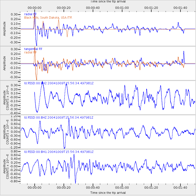
RSSD Black Hills, South Dakota, USA - Earthquake Result Viewer
*The percent match for this event was below the threshold and hence no stack was calculated.
| Earthquake location: |
Tonga Islands |
| Earthquake latitude/longitude: |
-15.2/-173.3 |
| Earthquake time(UTC): |
2004/10/09 (283) 15:44:24 GMT |
| Earthquake Depth: |
10 km |
| Earthquake Magnitude: |
5.5 MB, 5.7 MS, 5.9 MW, 5.8 MW |
| Earthquake Catalog/Contributor: |
WHDF/NEIC |
|
| Network: |
IU Global Seismograph Network (GSN - IRIS/USGS) |
| Station: |
RSSD Black Hills, South Dakota, USA |
| Lat/Lon: |
44.12 N/104.04 W |
| Elevation: |
2060 m |
|
| Distance: |
86.2 deg |
| Az: |
42.45 deg |
| Baz: |
244.802 deg |
| Ray Param: |
$rayparam |
*The percent match for this event was below the threshold and hence was not used in the summary stack. |
|
| Radial Match: |
57.845257 % |
| Radial Bump: |
400 |
| Transverse Match: |
60.82361 % |
| Transverse Bump: |
400 |
| SOD ConfigId: |
590571 |
| Insert Time: |
2013-09-25 07:29:16.528 +0000 |
| GWidth: |
2.5 |
| Max Bumps: |
400 |
| Tol: |
0.001 |
|
Signal To Noise
| Channel | StoN | STA | LTA |
| IU:RSSD:00:BHZ:20041009T15:56:34.497981Z | 2.575681 | 4.672904E-7 | 1.8142403E-7 |
| IU:RSSD:00:BH1:20041009T15:56:34.497981Z | 1.5094466 | 2.62243E-7 | 1.7373452E-7 |
| IU:RSSD:00:BH2:20041009T15:56:34.497981Z | 0.5720787 | 1.0593246E-7 | 1.8517112E-7 |
| Arrivals |
| Ps | |
| PpPs | |
| PsPs/PpSs | |


