You are here: Home > Network List > CN - Canadian National Seismograph Network Stations List
> Station WHY Whitehorse, YT > Earthquake Result Viewer
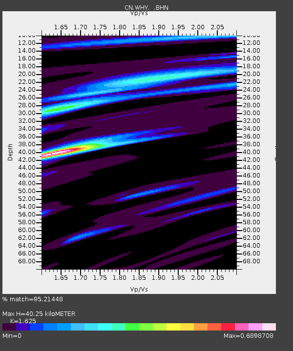
WHY Whitehorse, YT - Earthquake Result Viewer
| Earthquake location: |
Near Coast Of Guatemala |
| Earthquake latitude/longitude: |
13.6/-90.6 |
| Earthquake time(UTC): |
2007/06/13 (164) 19:29:40 GMT |
| Earthquake Depth: |
23 km |
| Earthquake Magnitude: |
5.9 MB, 6.5 MS, 6.7 MW, 6.5 MW |
| Earthquake Catalog/Contributor: |
WHDF/NEIC |
|
| Network: |
CN Canadian National Seismograph Network |
| Station: |
WHY Whitehorse, YT |
| Lat/Lon: |
60.66 N/134.88 W |
| Elevation: |
1292 m |
|
| Distance: |
56.9 deg |
| Az: |
335.783 deg |
| Baz: |
125.906 deg |
| Ray Param: |
0.063788444 |
| Estimated Moho Depth: |
40.25 km |
| Estimated Crust Vp/Vs: |
1.62 |
| Assumed Crust Vp: |
6.419 km/s |
| Estimated Crust Vs: |
3.95 km/s |
| Estimated Crust Poisson's Ratio: |
0.20 |
|
| Radial Match: |
95.21448 % |
| Radial Bump: |
379 |
| Transverse Match: |
85.083176 % |
| Transverse Bump: |
400 |
| SOD ConfigId: |
2564 |
| Insert Time: |
2010-02-27 07:48:53.689 +0000 |
| GWidth: |
2.5 |
| Max Bumps: |
400 |
| Tol: |
0.001 |
|

Signal To Noise
| Channel | StoN | STA | LTA |
| CN:WHY: :BHN:20070613T19:38:52.474006Z | 8.859307 | 5.810844E-7 | 6.559027E-8 |
| CN:WHY: :BHE:20070613T19:38:52.474006Z | 14.813353 | 7.5891336E-7 | 5.1231705E-8 |
| CN:WHY: :BHZ:20070613T19:38:52.474006Z | 31.372393 | 1.9652919E-6 | 6.264399E-8 |
| Arrivals |
| Ps | 4.1 SECOND |
| PpPs | 16 SECOND |
| PsPs/PpSs | 20 SECOND |


