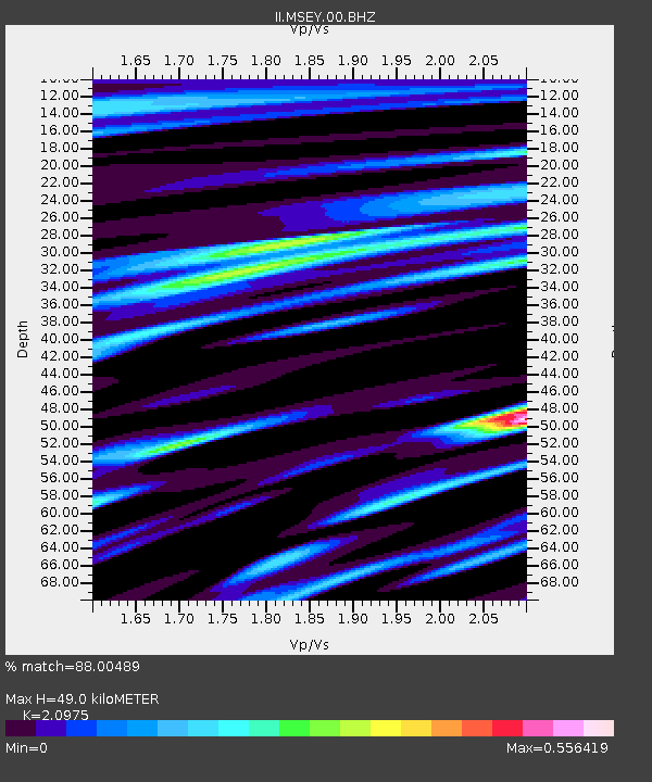
MSEY Mahe, Seychelles - Earthquake Result Viewer

Earthquake location: Near West Coast Of Honshu, Japan
Earthquake latitude/longitude: 37.2/138.8
Earthquake time(UTC): 2004/10/23 (297) 08:56:00 GMT
Earthquake Depth: 16 km
Earthquake Magnitude: 6.4 MB, 6.3 MS, 6.6 MW, 6.4 MW
Earthquake Catalog/Contributor: WHDF/NEIC
Network: II Global Seismograph Network (GSN - IRIS/IDA)
Station: MSEY Mahe, Seychelles
Lat/Lon: 4.67 S/55.48 E
Elevation: 475 m
Distance: 87.5 deg
Az: 262.254 deg
Baz: 52.516 deg
Ray Param: 0.043290194
Estimated Moho Depth: 49.0 km
Estimated Crust Vp/Vs: 2.10
Assumed Crust Vp: 6.303 km/s
Estimated Crust Vs: 3.005 km/s
Estimated Crust Poisson's Ratio: 0.35
Radial Match: 88.00489 %
Radial Bump: 400
Transverse Match: 69.51158 %
Transverse Bump: 400
SOD ConfigId: 590571
Insert Time: 2013-09-25 07:38:16.054 +0000
GWidth: 2.5
Max Bumps: 400
Tol: 0.001

Signal To Noise

ChannelStoNSTALTA
II:MSEY:00:BHZ:20041023T09:08:16.044021Z3.74588088.4919037E-72.2669978E-7
II:MSEY:00:BH1:20041023T09:08:16.044021Z1.46087183.0585514E-72.093648E-7
II:MSEY:00:BH2:20041023T09:08:16.044021Z1.62233052.5309907E-71.5600955E-7
Arrivals
Ps8.7 SECOND
PpPs24 SECOND
PsPs/PpSs32 SECOND