You are here: Home > Network List > IU - Global Seismograph Network (GSN - IRIS/USGS) Stations List
> Station RSSD Black Hills, South Dakota, USA > Earthquake Result Viewer
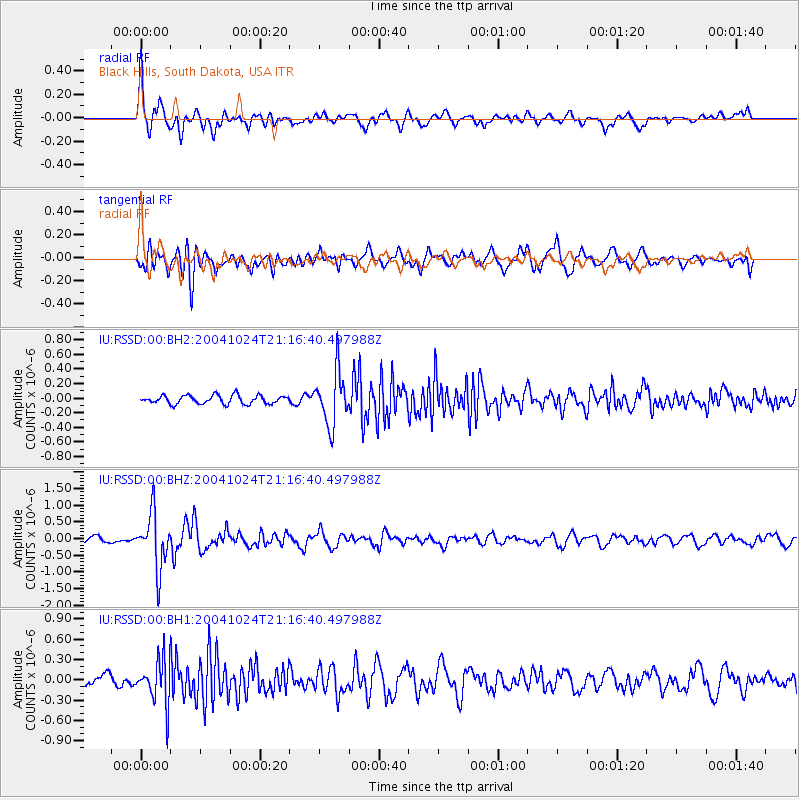
RSSD Black Hills, South Dakota, USA - Earthquake Result Viewer
*The percent match for this event was below the threshold and hence no stack was calculated.
| Earthquake location: |
Near West Coast Of Honshu, Japan |
| Earthquake latitude/longitude: |
37.3/138.7 |
| Earthquake time(UTC): |
2004/10/24 (298) 21:04:57 GMT |
| Earthquake Depth: |
11 km |
| Earthquake Magnitude: |
6.0 MB, 5.0 MS, 5.7 MW, 5.7 MW |
| Earthquake Catalog/Contributor: |
WHDF/NEIC |
|
| Network: |
IU Global Seismograph Network (GSN - IRIS/USGS) |
| Station: |
RSSD Black Hills, South Dakota, USA |
| Lat/Lon: |
44.12 N/104.04 W |
| Elevation: |
2060 m |
|
| Distance: |
81.0 deg |
| Az: |
40.399 deg |
| Baz: |
314.15 deg |
| Ray Param: |
$rayparam |
*The percent match for this event was below the threshold and hence was not used in the summary stack. |
|
| Radial Match: |
75.82308 % |
| Radial Bump: |
400 |
| Transverse Match: |
68.27005 % |
| Transverse Bump: |
400 |
| SOD ConfigId: |
590571 |
| Insert Time: |
2013-09-25 07:44:05.416 +0000 |
| GWidth: |
2.5 |
| Max Bumps: |
400 |
| Tol: |
0.001 |
|
Signal To Noise
| Channel | StoN | STA | LTA |
| IU:RSSD:00:BHZ:20041024T21:16:40.497988Z | 7.1963973 | 8.177739E-7 | 1.1363657E-7 |
| IU:RSSD:00:BH1:20041024T21:16:40.497988Z | 3.2735667 | 3.3239832E-7 | 1.015401E-7 |
| IU:RSSD:00:BH2:20041024T21:16:40.497988Z | 6.208172 | 3.6097063E-7 | 5.814443E-8 |
| Arrivals |
| Ps | |
| PpPs | |
| PsPs/PpSs | |


