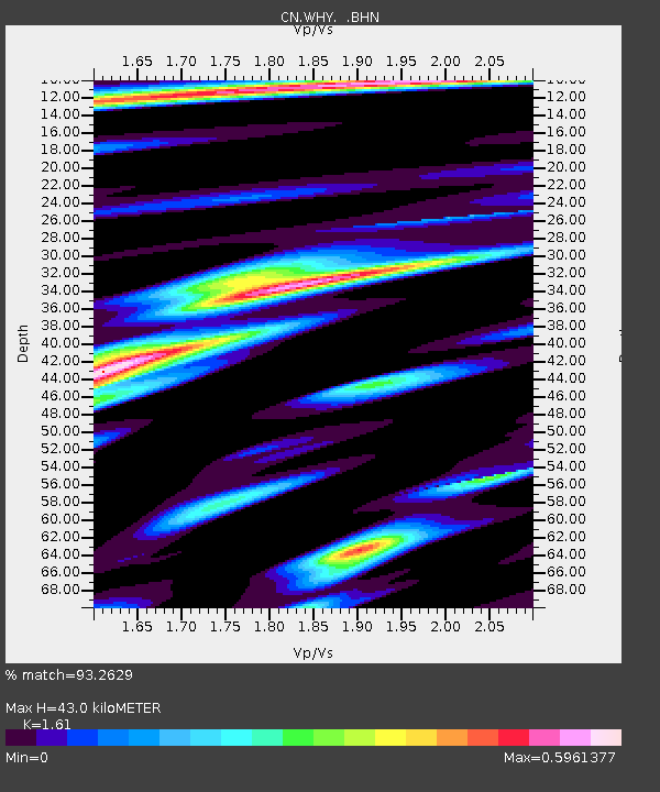
WHY Whitehorse, YT - Earthquake Result Viewer

Earthquake location: Off East Coast Of Honshu, Japan
Earthquake latitude/longitude: 37.6/142.2
Earthquake time(UTC): 2008/07/19 (201) 02:39:28 GMT
Earthquake Depth: 22 km
Earthquake Magnitude: 6.2 MB, 7.0 MS, 7.0 MW, 6.9 MW
Earthquake Catalog/Contributor: WHDF/NEIC
Network: CN Canadian National Seismograph Network
Station: WHY Whitehorse, YT
Lat/Lon: 60.66 N/134.88 W
Elevation: 1292 m
Distance: 54.8 deg
Az: 36.738 deg
Baz: 285.145 deg
Ray Param: 0.065192595
Estimated Moho Depth: 43.0 km
Estimated Crust Vp/Vs: 1.61
Assumed Crust Vp: 6.419 km/s
Estimated Crust Vs: 3.987 km/s
Estimated Crust Poisson's Ratio: 0.19
Radial Match: 93.2629 %
Radial Bump: 379
Transverse Match: 77.2504 %
Transverse Bump: 400
SOD ConfigId: 2504
Insert Time: 2010-02-27 07:49:41.595 +0000
GWidth: 2.5
Max Bumps: 400
Tol: 0.001

Signal To Noise

ChannelStoNSTALTA
CN:WHY: :BHN:20080719T02:48:25.850024Z6.02491148.3500913E-71.3859277E-7
CN:WHY: :BHE:20080719T02:48:25.850024Z1.55326821.434729E-79.23684E-8
CN:WHY: :BHZ:20080719T02:48:25.850024Z4.0218423.685974E-79.16489E-8
Arrivals
Ps4.3 SECOND
PpPs16 SECOND
PsPs/PpSs21 SECOND