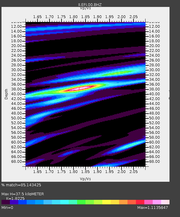
EFI Mount Kent, East Falkland Island - Earthquake Result Viewer

Earthquake location: Off W. Coast Of S. Island, N.Z.
Earthquake latitude/longitude: -46.7/164.7
Earthquake time(UTC): 2004/11/22 (327) 20:26:23 GMT
Earthquake Depth: 10 km
Earthquake Magnitude: 6.4 MB, 7.1 MS, 7.1 MW, 7.0 MW
Earthquake Catalog/Contributor: WHDF/NEIC
Network: II Global Seismograph Network (GSN - IRIS/IDA)
Station: EFI Mount Kent, East Falkland Island
Lat/Lon: 51.68 S/58.06 W
Elevation: 110 m
Distance: 75.4 deg
Az: 154.078 deg
Baz: 208.908 deg
Ray Param: 0.051722955
Estimated Moho Depth: 37.5 km
Estimated Crust Vp/Vs: 1.82
Assumed Crust Vp: 6.472 km/s
Estimated Crust Vs: 3.551 km/s
Estimated Crust Poisson's Ratio: 0.28
Radial Match: 85.143425 %
Radial Bump: 390
Transverse Match: 71.601234 %
Transverse Bump: 400
SOD ConfigId: 590571
Insert Time: 2013-09-25 08:19:25.486 +0000
GWidth: 2.5
Max Bumps: 400
Tol: 0.001

Signal To Noise

ChannelStoNSTALTA
II:EFI:00:BHZ:20041122T20:37:36.110022Z2.54235464.848292E-61.9070086E-6
II:EFI:00:BH1:20041122T20:37:36.110022Z2.00840882.8670092E-61.4275028E-6
II:EFI:00:BH2:20041122T20:37:36.110022Z1.24599819.763356E-77.835771E-7
Arrivals
Ps4.9 SECOND
PpPs16 SECOND
PsPs/PpSs21 SECOND