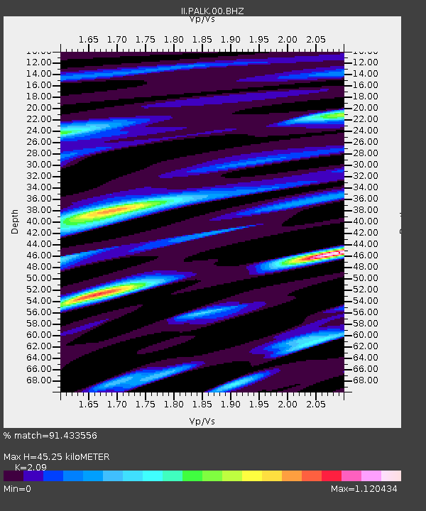
PALK Pallekele, Sri Lanka - Earthquake Result Viewer
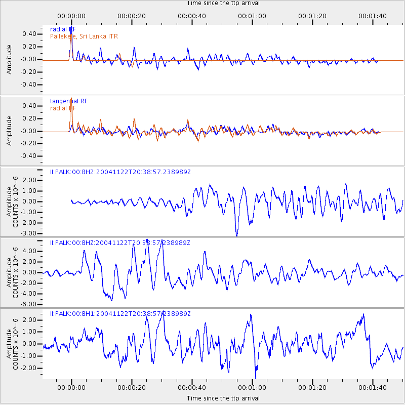
Earthquake location: Off W. Coast Of S. Island, N.Z.
Earthquake latitude/longitude: -46.7/164.7
Earthquake time(UTC): 2004/11/22 (327) 20:26:23 GMT
Earthquake Depth: 10 km
Earthquake Magnitude: 6.4 MB, 7.1 MS, 7.1 MW, 7.0 MW
Earthquake Catalog/Contributor: WHDF/NEIC
Network: II Global Seismograph Network (GSN - IRIS/IDA)
Station: PALK Pallekele, Sri Lanka
Lat/Lon: 7.27 N/80.70 E
Elevation: 460 m
Distance: 91.1 deg
Az: 279.299 deg
Baz: 136.769 deg
Ray Param: 0.0416228
Estimated Moho Depth: 45.25 km
Estimated Crust Vp/Vs: 2.09
Assumed Crust Vp: 6.545 km/s
Estimated Crust Vs: 3.132 km/s
Estimated Crust Poisson's Ratio: 0.35
Radial Match: 91.433556 %
Radial Bump: 400
Transverse Match: 75.80296 %
Transverse Bump: 400
SOD ConfigId: 590571
Insert Time: 2013-09-25 08:19:30.155 +0000
GWidth: 2.5
Max Bumps: 400
Tol: 0.001

Signal To Noise

ChannelStoNSTALTA
II:PALK:00:BHZ:20041122T20:38:57.238989Z7.52023551.6692386E-62.2196627E-7
II:PALK:00:BH1:20041122T20:38:57.238989Z2.06662136.9010787E-73.339305E-7
II:PALK:00:BH2:20041122T20:38:57.238989Z2.06176073.5932348E-71.7427992E-7
Arrivals
Ps7.7 SECOND
PpPs21 SECOND
PsPs/PpSs29 SECOND