You are here: Home > Network List > ER - Mount Erebus Volcano Observatory Seismic Network Stations List
> Station E1S PLACE HOLDER, Mt. Erebus Volcano Seismic Network > Earthquake Result Viewer
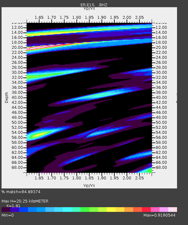
E1S PLACE HOLDER, Mt. Erebus Volcano Seismic Network - Earthquake Result Viewer
| Earthquake location: |
Easter Island Region |
| Earthquake latitude/longitude: |
-26.5/-113.8 |
| Earthquake time(UTC): |
2004/11/28 (333) 02:35:13 GMT |
| Earthquake Depth: |
10 km |
| Earthquake Magnitude: |
5.6 MB, 6.1 MS, 6.6 MW, 6.5 MW |
| Earthquake Catalog/Contributor: |
WHDF/NEIC |
|
| Network: |
ER Mount Erebus Volcano Observatory Seismic Network |
| Station: |
E1S PLACE HOLDER, Mt. Erebus Volcano Seismic Network |
| Lat/Lon: |
77.53 S/167.14 E |
| Elevation: |
3712 m |
|
| Distance: |
61.9 deg |
| Az: |
193.992 deg |
| Baz: |
85.453 deg |
| Ray Param: |
0.060564965 |
| Estimated Moho Depth: |
20.25 km |
| Estimated Crust Vp/Vs: |
1.61 |
| Assumed Crust Vp: |
6.183 km/s |
| Estimated Crust Vs: |
3.84 km/s |
| Estimated Crust Poisson's Ratio: |
0.19 |
|
| Radial Match: |
94.69374 % |
| Radial Bump: |
373 |
| Transverse Match: |
68.502625 % |
| Transverse Bump: |
400 |
| SOD ConfigId: |
590571 |
| Insert Time: |
2013-09-25 08:24:19.534 +0000 |
| GWidth: |
2.5 |
| Max Bumps: |
400 |
| Tol: |
0.001 |
|

Signal To Noise
| Channel | StoN | STA | LTA |
| ER:E1S: :BHZ:20041128T02:45:02.02499Z | 3.006807 | 5.408489E-7 | 1.7987482E-7 |
| ER:E1S: :BH1:20041128T02:45:02.02499Z | 2.5695913 | 5.5612617E-7 | 2.1642592E-7 |
| ER:E1S: :BH2:20041128T02:45:02.02499Z | 0.9446947 | 3.0939123E-7 | 3.2750393E-7 |
| Arrivals |
| Ps | 2.1 SECOND |
| PpPs | 8.2 SECOND |
| PsPs/PpSs | 10 SECOND |


