COCO West Island, Cocos (Keeling) Islands - Earthquake Result Viewer
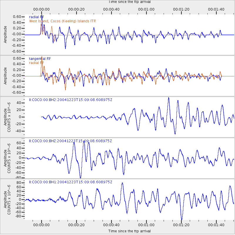
Earthquake location: North Of Macquarie Island
Earthquake latitude/longitude: -49.3/161.3
Earthquake time(UTC): 2004/12/23 (358) 14:59:04 GMT
Earthquake Depth: 10 km
Earthquake Magnitude: 8.0 MW, 6.5 MB, 7.7 MS, 8.1 MW
Earthquake Catalog/Contributor: NEIC PDE/NEIC PDE-M
Network: II Global Seismograph Network (GSN - IRIS/IDA)
Station: COCO West Island, Cocos (Keeling) Islands
Lat/Lon: 12.19 S/96.83 E
Elevation: 1.0 m
Distance: 64.3 deg
Az: 281.58 deg
Baz: 139.025 deg
Ray Param: 0.05902458
Estimated Moho Depth: 16.5 km
Estimated Crust Vp/Vs: 1.80
Assumed Crust Vp: 4.24 km/s
Estimated Crust Vs: 2.356 km/s
Estimated Crust Poisson's Ratio: 0.28
Radial Match: 88.983955 %
Radial Bump: 400
Transverse Match: 88.85577 %
Transverse Bump: 346
SOD ConfigId: 590571
Insert Time: 2013-09-25 08:43:58.186 +0000
GWidth: 2.5
Max Bumps: 400
Tol: 0.001

Signal To Noise

ChannelStoNSTALTA
II:COCO:00:BHZ:20041223T15:09:08.608975Z3.08316063.7636266E-61.220704E-6
II:COCO:00:BH1:20041223T15:09:08.608975Z0.9753072.7674669E-62.837534E-6
II:COCO:00:BH2:20041223T15:09:08.608975Z0.466445361.4067701E-63.0159376E-6
Arrivals
Ps3.2 SECOND
PpPs11 SECOND
PsPs/PpSs14 SECOND