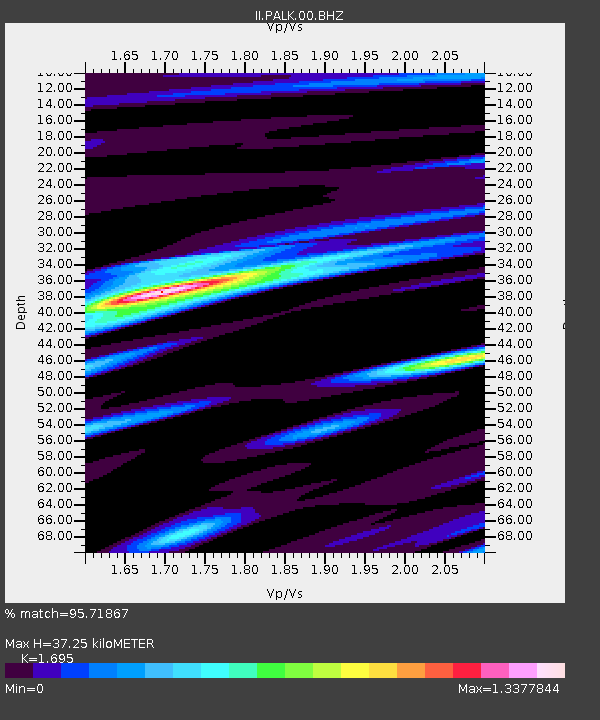
PALK Pallekele, Sri Lanka - Earthquake Result Viewer
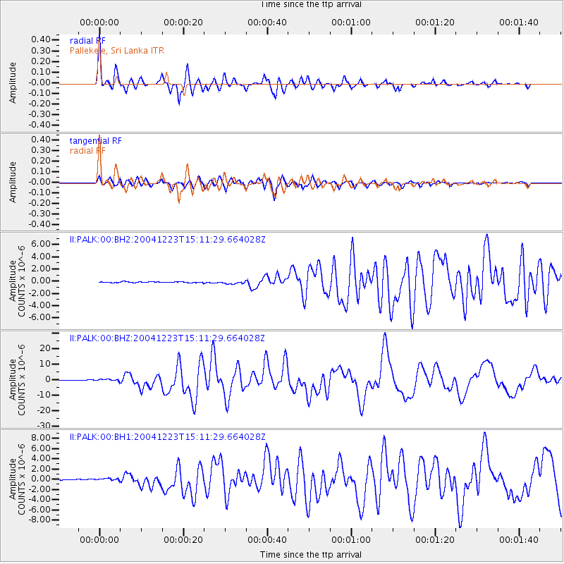
Earthquake location: North Of Macquarie Island
Earthquake latitude/longitude: -49.3/161.3
Earthquake time(UTC): 2004/12/23 (358) 14:59:04 GMT
Earthquake Depth: 10 km
Earthquake Magnitude: 8.0 MW, 6.5 MB, 7.7 MS, 8.1 MW
Earthquake Catalog/Contributor: NEIC PDE/NEIC PDE-M
Network: II Global Seismograph Network (GSN - IRIS/IDA)
Station: PALK Pallekele, Sri Lanka
Lat/Lon: 7.27 N/80.70 E
Elevation: 460 m
Distance: 89.4 deg
Az: 281.787 deg
Baz: 139.776 deg
Ray Param: 0.041877933
Estimated Moho Depth: 37.25 km
Estimated Crust Vp/Vs: 1.70
Assumed Crust Vp: 6.545 km/s
Estimated Crust Vs: 3.862 km/s
Estimated Crust Poisson's Ratio: 0.23
Radial Match: 95.71867 %
Radial Bump: 339
Transverse Match: 89.3508 %
Transverse Bump: 400
SOD ConfigId: 590571
Insert Time: 2013-09-25 08:44:03.619 +0000
GWidth: 2.5
Max Bumps: 400
Tol: 0.001

Signal To Noise

ChannelStoNSTALTA
II:PALK:00:BHZ:20041223T15:11:29.664028Z4.4983987.2244086E-71.605996E-7
II:PALK:00:BH1:20041223T15:11:29.664028Z2.7335962.4121198E-78.8239794E-8
II:PALK:00:BH2:20041223T15:11:29.664028Z3.02764252.1706897E-77.169571E-8
Arrivals
Ps4.0 SECOND
PpPs15 SECOND
PsPs/PpSs19 SECOND