You are here: Home > Network List > CN - Canadian National Seismograph Network Stations List
> Station WHY Whitehorse, YT > Earthquake Result Viewer
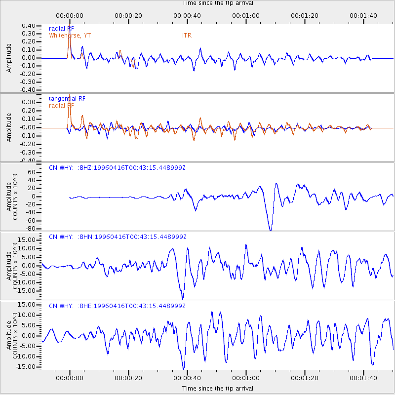
WHY Whitehorse, YT - Earthquake Result Viewer

| Earthquake location: |
South Of Fiji Islands |
| Earthquake latitude/longitude: |
-24.1/-177.0 |
| Earthquake time(UTC): |
1996/04/16 (107) 00:30:54 GMT |
| Earthquake Depth: |
111 km |
| Earthquake Magnitude: |
6.4 MB, 6.8 MS, 7.1 UNKNOWN, 7.1 MW |
| Earthquake Catalog/Contributor: |
WHDF/NEIC |
|
| Network: |
CN Canadian National Seismograph Network |
| Station: |
WHY Whitehorse, YT |
| Lat/Lon: |
60.66 N/134.88 W |
| Elevation: |
1292 m |
|
| Distance: |
91.1 deg |
| Az: |
19.305 deg |
| Baz: |
217.852 deg |
| Ray Param: |
0.04160448 |
| Estimated Moho Depth: |
39.0 km |
| Estimated Crust Vp/Vs: |
1.72 |
| Assumed Crust Vp: |
6.419 km/s |
| Estimated Crust Vs: |
3.727 km/s |
| Estimated Crust Poisson's Ratio: |
0.25 |
|
| Radial Match: |
94.006 % |
| Radial Bump: |
400 |
| Transverse Match: |
80.62866 % |
| Transverse Bump: |
400 |
| SOD ConfigId: |
6273 |
| Insert Time: |
2010-02-27 07:51:45.838 +0000 |
| GWidth: |
2.5 |
| Max Bumps: |
400 |
| Tol: |
0.001 |
|
Signal To Noise
| Channel | StoN | STA | LTA |
| CN:WHY: :BHN:19960416T00:43:15.448999Z | 1.2661691 | 1121.5724 | 885.7998 |
| CN:WHY: :BHE:19960416T00:43:15.448999Z | 0.8504092 | 1050.2834 | 1235.033 |
| CN:WHY: :BHZ:19960416T00:43:15.448999Z | 2.6311395 | 2616.5427 | 994.4522 |
| Arrivals |
| Ps | 4.5 SECOND |
| PpPs | 16 SECOND |
| PsPs/PpSs | 21 SECOND |


