You are here: Home > Network List > II - Global Seismograph Network (GSN - IRIS/IDA) Stations List
> Station MBAR Mbarara, Uganda > Earthquake Result Viewer
MBAR Mbarara, Uganda - Earthquake Result Viewer

| Earthquake location: |
Andaman Islands, India Region |
| Earthquake latitude/longitude: |
13.1/93.0 |
| Earthquake time(UTC): |
2004/12/26 (361) 07:38:27 GMT |
| Earthquake Depth: |
30 km |
| Earthquake Magnitude: |
5.7 MB |
| Earthquake Catalog/Contributor: |
NEIC PDE/NEIC PDE-M |
|
| Network: |
II Global Seismograph Network (GSN - IRIS/IDA) |
| Station: |
MBAR Mbarara, Uganda |
| Lat/Lon: |
0.60 S/30.74 E |
| Elevation: |
1390 m |
|
| Distance: |
63.2 deg |
| Az: |
262.593 deg |
| Baz: |
75.042 deg |
| Ray Param: |
0.059669696 |
| Estimated Moho Depth: |
48.25 km |
| Estimated Crust Vp/Vs: |
2.07 |
| Assumed Crust Vp: |
6.419 km/s |
| Estimated Crust Vs: |
3.097 km/s |
| Estimated Crust Poisson's Ratio: |
0.35 |
|
| Radial Match: |
81.316284 % |
| Radial Bump: |
343 |
| Transverse Match: |
74.19586 % |
| Transverse Bump: |
320 |
| SOD ConfigId: |
590571 |
| Insert Time: |
2013-09-25 08:58:54.438 +0000 |
| GWidth: |
2.5 |
| Max Bumps: |
400 |
| Tol: |
0.001 |
|
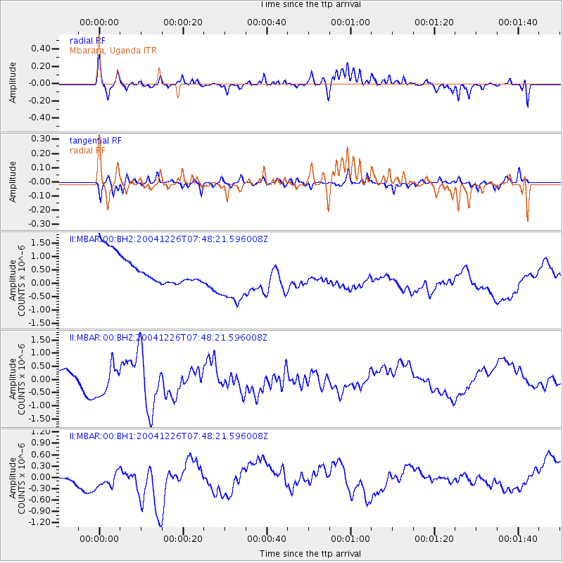
Signal To Noise
| Channel | StoN | STA | LTA |
| II:MBAR:00:BHZ:20041226T07:48:21.596008Z | 2.089556 | 5.4289677E-7 | 2.598144E-7 |
| II:MBAR:00:BH1:20041226T07:48:21.596008Z | 1.300285 | 5.1354226E-7 | 3.949459E-7 |
| II:MBAR:00:BH2:20041226T07:48:21.596008Z | 1.9517189 | 1.0632662E-6 | 5.447845E-7 |
| Arrivals |
| Ps | 8.4 SECOND |
| PpPs | 22 SECOND |
| PsPs/PpSs | 31 SECOND |


