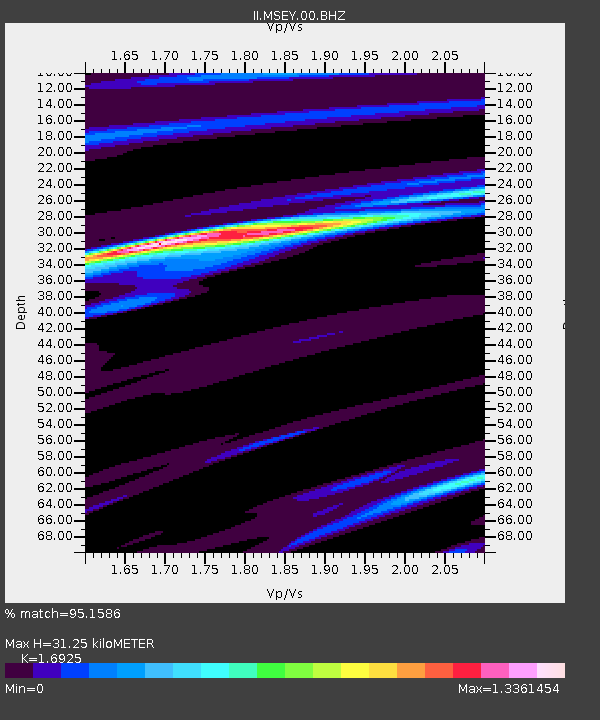
MSEY Mahe, Seychelles - Earthquake Result Viewer

Earthquake location: Nicobar Islands, India Region
Earthquake latitude/longitude: 8.9/92.4
Earthquake time(UTC): 2004/12/26 (361) 09:20:01 GMT
Earthquake Depth: 16 km
Earthquake Magnitude: 6.0 MB, 6.4 ME, 6.6 MW, 6.6 MS
Earthquake Catalog/Contributor: NEIC PDE/NEIC PDE-M
Network: II Global Seismograph Network (GSN - IRIS/IDA)
Station: MSEY Mahe, Seychelles
Lat/Lon: 4.67 S/55.48 E
Elevation: 475 m
Distance: 39.2 deg
Az: 251.329 deg
Baz: 69.926 deg
Ray Param: 0.0751232
Estimated Moho Depth: 31.25 km
Estimated Crust Vp/Vs: 1.69
Assumed Crust Vp: 6.303 km/s
Estimated Crust Vs: 3.724 km/s
Estimated Crust Poisson's Ratio: 0.23
Radial Match: 95.1586 %
Radial Bump: 277
Transverse Match: 45.074932 %
Transverse Bump: 400
SOD ConfigId: 590571
Insert Time: 2013-09-25 08:59:47.928 +0000
GWidth: 2.5
Max Bumps: 400
Tol: 0.001

Signal To Noise

ChannelStoNSTALTA
II:MSEY:00:BHZ:20041226T09:26:57.797988Z3.2950069.2049817E-72.7936161E-7
II:MSEY:00:BH1:20041226T09:26:57.797988Z3.0467036.0431177E-71.983494E-7
II:MSEY:00:BH2:20041226T09:26:57.797988Z0.94850923.8470188E-74.055858E-7
Arrivals
Ps3.7 SECOND
PpPs12 SECOND
PsPs/PpSs16 SECOND