You are here: Home > Network List > TA - USArray Transportable Network (new EarthScope stations) Stations List
> Station L04D Klamath Falls, OR, USA > Earthquake Result Viewer
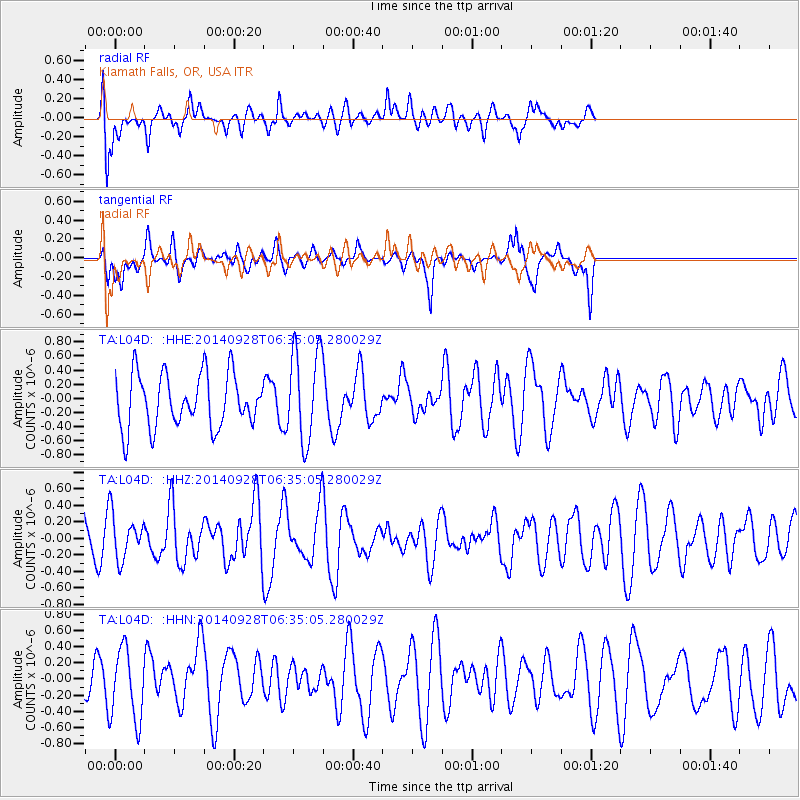
L04D Klamath Falls, OR, USA - Earthquake Result Viewer
*The percent match for this event was below the threshold and hence no stack was calculated.
| Earthquake location: |
Fiji Islands Region |
| Earthquake latitude/longitude: |
-19.1/-176.3 |
| Earthquake time(UTC): |
2014/09/28 (271) 06:23:35 GMT |
| Earthquake Depth: |
10 km |
| Earthquake Magnitude: |
5.7 MWC, 5.7 MWC |
| Earthquake Catalog/Contributor: |
NEIC PDE/NEIC COMCAT |
|
| Network: |
TA USArray Transportable Network (new EarthScope stations) |
| Station: |
L04D Klamath Falls, OR, USA |
| Lat/Lon: |
42.22 N/122.30 W |
| Elevation: |
1437 m |
|
| Distance: |
78.8 deg |
| Az: |
37.803 deg |
| Baz: |
231.272 deg |
| Ray Param: |
$rayparam |
*The percent match for this event was below the threshold and hence was not used in the summary stack. |
|
| Radial Match: |
62.09334 % |
| Radial Bump: |
400 |
| Transverse Match: |
46.512974 % |
| Transverse Bump: |
352 |
| SOD ConfigId: |
3390531 |
| Insert Time: |
2019-04-14 06:08:44.054 +0000 |
| GWidth: |
2.5 |
| Max Bumps: |
400 |
| Tol: |
0.001 |
|
Signal To Noise
| Channel | StoN | STA | LTA |
| TA:L04D: :HHZ:20140928T06:35:05.280029Z | 0.9916002 | 2.588444E-7 | 2.610371E-7 |
| TA:L04D: :HHN:20140928T06:35:05.280029Z | 1.0558525 | 4.3300392E-7 | 4.1009886E-7 |
| TA:L04D: :HHE:20140928T06:35:05.280029Z | 1.6675367 | 5.96768E-7 | 3.5787397E-7 |
| Arrivals |
| Ps | |
| PpPs | |
| PsPs/PpSs | |


