You are here: Home > Network List > II - Global Seismograph Network (GSN - IRIS/IDA) Stations List
> Station MSEY Mahe, Seychelles > Earthquake Result Viewer
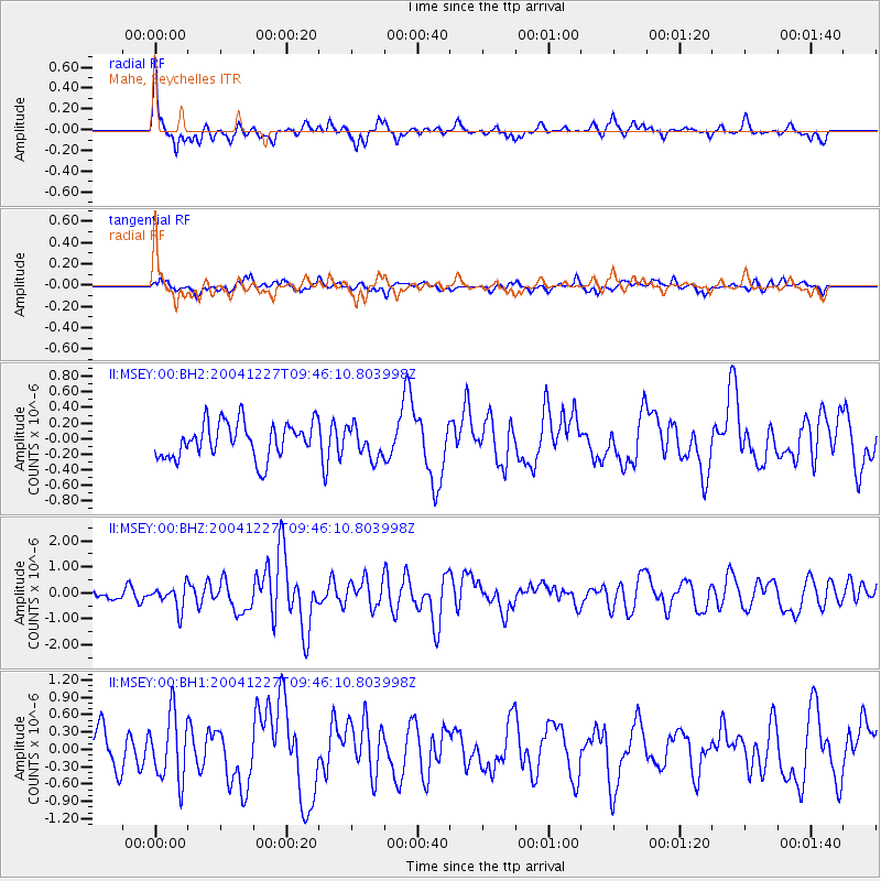
MSEY Mahe, Seychelles - Earthquake Result Viewer
*The percent match for this event was below the threshold and hence no stack was calculated.
| Earthquake location: |
Northern Sumatra, Indonesia |
| Earthquake latitude/longitude: |
5.3/94.7 |
| Earthquake time(UTC): |
2004/12/27 (362) 09:39:06 GMT |
| Earthquake Depth: |
35 km |
| Earthquake Magnitude: |
6.1 MW, 5.9 MS, 6.0 MW, 6.2 MB |
| Earthquake Catalog/Contributor: |
NEIC PDE/NEIC PDE-M |
|
| Network: |
II Global Seismograph Network (GSN - IRIS/IDA) |
| Station: |
MSEY Mahe, Seychelles |
| Lat/Lon: |
4.67 S/55.48 E |
| Elevation: |
475 m |
|
| Distance: |
40.4 deg |
| Az: |
256.415 deg |
| Baz: |
76.176 deg |
| Ray Param: |
$rayparam |
*The percent match for this event was below the threshold and hence was not used in the summary stack. |
|
| Radial Match: |
71.13915 % |
| Radial Bump: |
386 |
| Transverse Match: |
46.867588 % |
| Transverse Bump: |
400 |
| SOD ConfigId: |
590571 |
| Insert Time: |
2013-09-25 09:09:23.277 +0000 |
| GWidth: |
2.5 |
| Max Bumps: |
400 |
| Tol: |
0.001 |
|
Signal To Noise
| Channel | StoN | STA | LTA |
| II:MSEY:00:BHZ:20041227T09:46:10.803998Z | 1.4410623 | 4.4657136E-7 | 3.0989037E-7 |
| II:MSEY:00:BH1:20041227T09:46:10.803998Z | 2.1568575 | 5.6612265E-7 | 2.624757E-7 |
| II:MSEY:00:BH2:20041227T09:46:10.803998Z | 0.8833808 | 2.005872E-7 | 2.2706764E-7 |
| Arrivals |
| Ps | |
| PpPs | |
| PsPs/PpSs | |


