You are here: Home > Network List > II - Global Seismograph Network (GSN - IRIS/IDA) Stations List
> Station MBAR Mbarara, Uganda > Earthquake Result Viewer
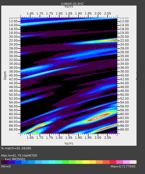
MBAR Mbarara, Uganda - Earthquake Result Viewer
| Earthquake location: |
Andaman Islands, India Region |
| Earthquake latitude/longitude: |
12.4/92.5 |
| Earthquake time(UTC): |
2004/12/27 (362) 14:46:46 GMT |
| Earthquake Depth: |
19 km |
| Earthquake Magnitude: |
5.8 MB, 5.6 MW |
| Earthquake Catalog/Contributor: |
NEIC PDE/NEIC PDE-M |
|
| Network: |
II Global Seismograph Network (GSN - IRIS/IDA) |
| Station: |
MBAR Mbarara, Uganda |
| Lat/Lon: |
0.60 S/30.74 E |
| Elevation: |
1390 m |
|
| Distance: |
62.6 deg |
| Az: |
262.827 deg |
| Baz: |
75.827 deg |
| Ray Param: |
0.06011482 |
| Estimated Moho Depth: |
61.75 km |
| Estimated Crust Vp/Vs: |
1.99 |
| Assumed Crust Vp: |
6.419 km/s |
| Estimated Crust Vs: |
3.222 km/s |
| Estimated Crust Poisson's Ratio: |
0.33 |
|
| Radial Match: |
81.06365 % |
| Radial Bump: |
316 |
| Transverse Match: |
79.75932 % |
| Transverse Bump: |
400 |
| SOD ConfigId: |
590571 |
| Insert Time: |
2013-09-25 09:10:35.191 +0000 |
| GWidth: |
2.5 |
| Max Bumps: |
400 |
| Tol: |
0.001 |
|

Signal To Noise
| Channel | StoN | STA | LTA |
| II:MBAR:00:BHZ:20041227T14:56:38.133982Z | 9.033892 | 4.8124804E-7 | 5.3271396E-8 |
| II:MBAR:00:BH1:20041227T14:56:38.133982Z | 4.8704853 | 1.7619112E-7 | 3.617527E-8 |
| II:MBAR:00:BH2:20041227T14:56:38.133982Z | 4.7558255 | 1.8625246E-7 | 3.9163016E-8 |
| Arrivals |
| Ps | 9.9 SECOND |
| PpPs | 28 SECOND |
| PsPs/PpSs | 38 SECOND |


