You are here: Home > Network List > II - Global Seismograph Network (GSN - IRIS/IDA) Stations List
> Station MBAR Mbarara, Uganda > Earthquake Result Viewer
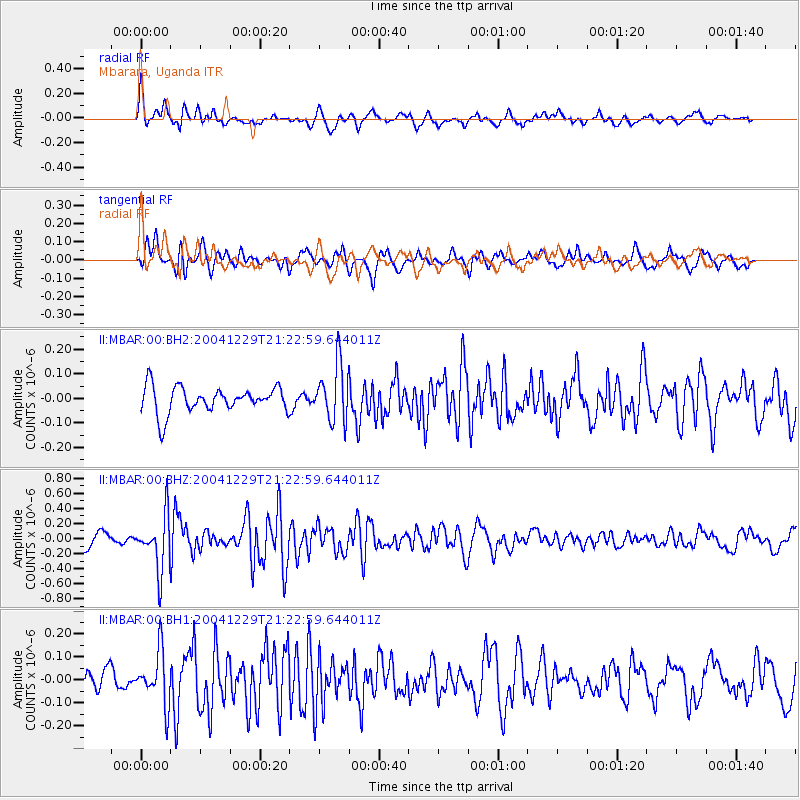
MBAR Mbarara, Uganda - Earthquake Result Viewer
*The percent match for this event was below the threshold and hence no stack was calculated.
| Earthquake location: |
Northern Sumatra, Indonesia |
| Earthquake latitude/longitude: |
5.2/94.6 |
| Earthquake time(UTC): |
2004/12/29 (364) 21:12:59 GMT |
| Earthquake Depth: |
30 km |
| Earthquake Magnitude: |
5.6 MW, 5.6 MW, 5.7 MB |
| Earthquake Catalog/Contributor: |
NEIC PDE/NEIC PDE-M |
|
| Network: |
II Global Seismograph Network (GSN - IRIS/IDA) |
| Station: |
MBAR Mbarara, Uganda |
| Lat/Lon: |
0.60 S/30.74 E |
| Elevation: |
1390 m |
|
| Distance: |
64.1 deg |
| Az: |
266.797 deg |
| Baz: |
83.928 deg |
| Ray Param: |
$rayparam |
*The percent match for this event was below the threshold and hence was not used in the summary stack. |
|
| Radial Match: |
66.3874 % |
| Radial Bump: |
400 |
| Transverse Match: |
74.73863 % |
| Transverse Bump: |
400 |
| SOD ConfigId: |
590571 |
| Insert Time: |
2013-09-25 09:17:03.407 +0000 |
| GWidth: |
2.5 |
| Max Bumps: |
400 |
| Tol: |
0.001 |
|
Signal To Noise
| Channel | StoN | STA | LTA |
| II:MBAR:00:BHZ:20041229T21:22:59.644011Z | 4.4861674 | 3.5979704E-7 | 8.020143E-8 |
| II:MBAR:00:BH1:20041229T21:22:59.644011Z | 2.1070623 | 1.1461486E-7 | 5.4395578E-8 |
| II:MBAR:00:BH2:20041229T21:22:59.644011Z | 2.1608474 | 1.14790964E-7 | 5.3123127E-8 |
| Arrivals |
| Ps | |
| PpPs | |
| PsPs/PpSs | |


