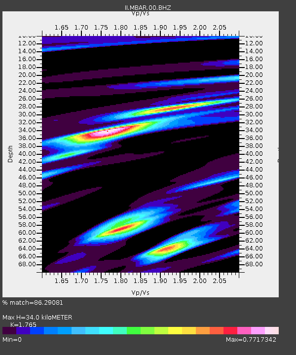
MBAR Mbarara, Uganda - Earthquake Result Viewer

Earthquake location: Andaman Islands, India Region
Earthquake latitude/longitude: 10.7/92.4
Earthquake time(UTC): 2005/01/04 (004) 09:13:12 GMT
Earthquake Depth: 23 km
Earthquake Magnitude: 6.0 MB, 5.9 MS, 6.1 MW, 6.1 MW
Earthquake Catalog/Contributor: WHDF/NEIC
Network: II Global Seismograph Network (GSN - IRIS/IDA)
Station: MBAR Mbarara, Uganda
Lat/Lon: 0.60 S/30.74 E
Elevation: 1390 m
Distance: 62.3 deg
Az: 263.664 deg
Baz: 77.682 deg
Ray Param: 0.0603024
Estimated Moho Depth: 34.0 km
Estimated Crust Vp/Vs: 1.76
Assumed Crust Vp: 6.419 km/s
Estimated Crust Vs: 3.637 km/s
Estimated Crust Poisson's Ratio: 0.26
Radial Match: 86.29081 %
Radial Bump: 394
Transverse Match: 84.85075 %
Transverse Bump: 400
SOD ConfigId: 590571
Insert Time: 2013-09-25 09:24:40.976 +0000
GWidth: 2.5
Max Bumps: 400
Tol: 0.001

Signal To Noise

ChannelStoNSTALTA
II:MBAR:00:BHZ:20050104T09:23:01.296997Z3.6886483.9438325E-71.0691811E-7
II:MBAR:00:BH1:20050104T09:23:01.296997Z1.58483831.280629E-78.080502E-8
II:MBAR:00:BH2:20050104T09:23:01.296997Z2.2332052.1219932E-79.5020084E-8
Arrivals
Ps4.2 SECOND
PpPs14 SECOND
PsPs/PpSs18 SECOND