You are here: Home > Network List > CN - Canadian National Seismograph Network Stations List
> Station WHY Whitehorse, YT > Earthquake Result Viewer
WHY Whitehorse, YT - Earthquake Result Viewer
| Earthquake location: |
Halmahera, Indonesia |
| Earthquake latitude/longitude: |
-1.9/127.9 |
| Earthquake time(UTC): |
1997/06/24 (175) 23:04:53 GMT |
| Earthquake Depth: |
33 km |
| Earthquake Magnitude: |
5.9 MB, 6.1 MS, 6.4 UNKNOWN, 6.1 MS |
| Earthquake Catalog/Contributor: |
WHDF/NEIC |
|
| Network: |
CN Canadian National Seismograph Network |
| Station: |
WHY Whitehorse, YT |
| Lat/Lon: |
60.66 N/134.88 W |
| Elevation: |
1292 m |
|
| Distance: |
95.2 deg |
| Az: |
29.382 deg |
| Baz: |
275.353 deg |
| Ray Param: |
0.040827136 |
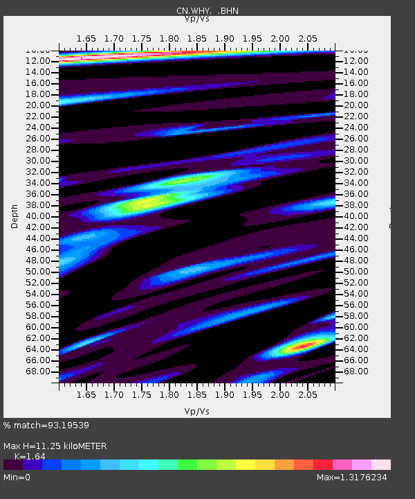
| Estimated Moho Depth: |
11.25 km |
| Estimated Crust Vp/Vs: |
1.64 |
| Assumed Crust Vp: |
6.419 km/s |
| Estimated Crust Vs: |
3.914 km/s |
| Estimated Crust Poisson's Ratio: |
0.20 |
|
| Radial Match: |
93.19539 % |
| Radial Bump: |
400 |
| Transverse Match: |
83.83542 % |
| Transverse Bump: |
400 |
| SOD ConfigId: |
6273 |
| Insert Time: |
2010-02-27 07:53:15.083 +0000 |
| GWidth: |
2.5 |
| Max Bumps: |
400 |
| Tol: |
0.001 |
|
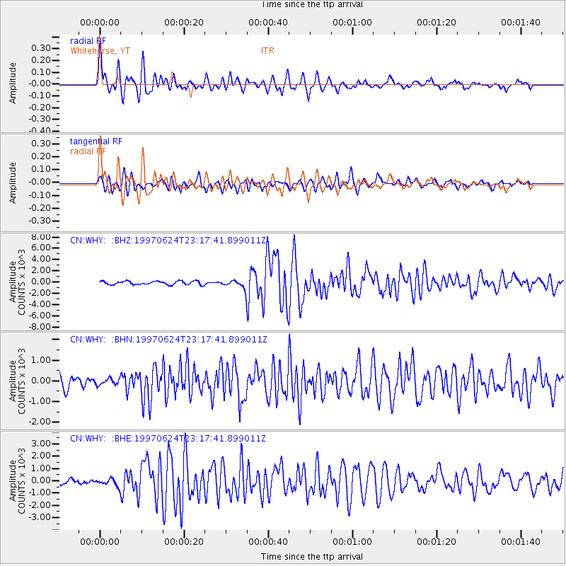
Signal To Noise
| Channel | StoN | STA | LTA |
| CN:WHY: :BHN:19970624T23:17:41.899011Z | 0.6294594 | 146.94003 | 233.43849 |
| CN:WHY: :BHE:19970624T23:17:41.899011Z | 1.9502118 | 295.62027 | 151.58368 |
| CN:WHY: :BHZ:19970624T23:17:41.899011Z | 2.574693 | 787.02356 | 305.6767 |
| Arrivals |
| Ps | 1.1 SECOND |
| PpPs | 4.5 SECOND |
| PsPs/PpSs | 5.7 SECOND |


