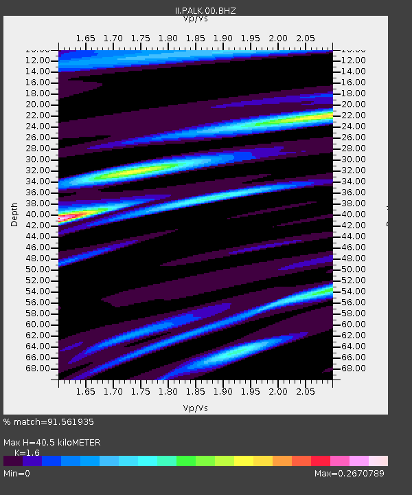
PALK Pallekele, Sri Lanka - Earthquake Result Viewer
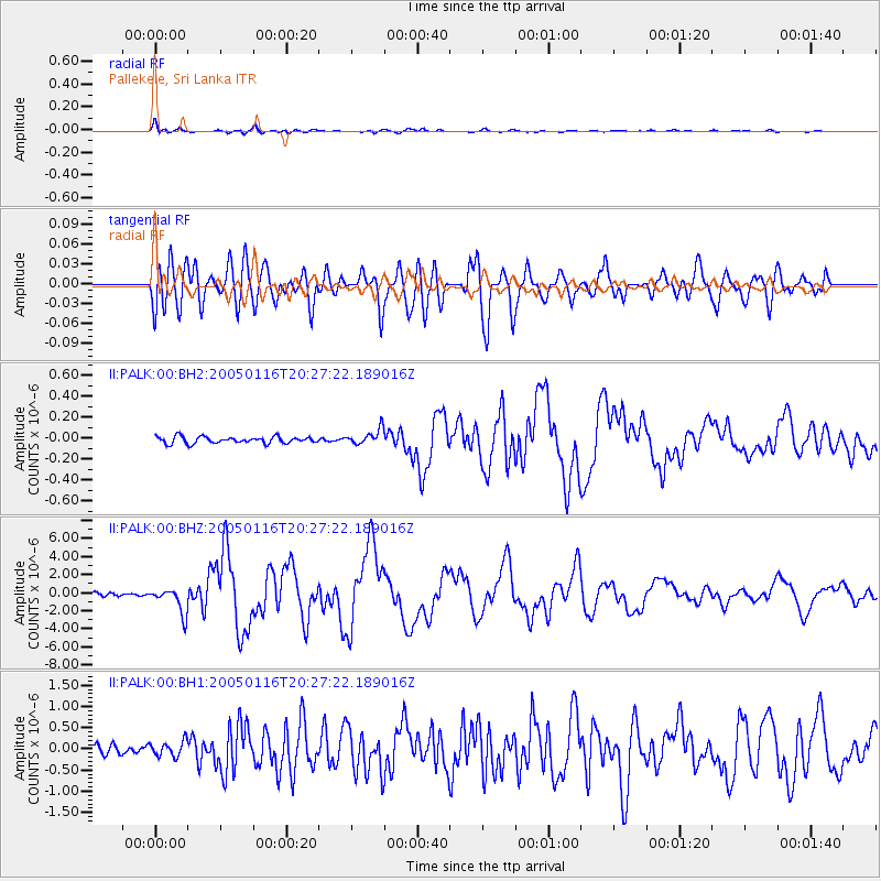
Earthquake location: W. Caroline Islands, Micronesia
Earthquake latitude/longitude: 10.9/140.8
Earthquake time(UTC): 2005/01/16 (016) 20:17:52 GMT
Earthquake Depth: 25 km
Earthquake Magnitude: 6.3 MB, 6.7 MS, 6.6 MW, 6.6 MW
Earthquake Catalog/Contributor: WHDF/NEIC
Network: II Global Seismograph Network (GSN - IRIS/IDA)
Station: PALK Pallekele, Sri Lanka
Lat/Lon: 7.27 N/80.70 E
Elevation: 460 m
Distance: 59.4 deg
Az: 272.025 deg
Baz: 81.62 deg
Ray Param: 0.06216606
Estimated Moho Depth: 40.5 km
Estimated Crust Vp/Vs: 1.60
Assumed Crust Vp: 6.545 km/s
Estimated Crust Vs: 4.091 km/s
Estimated Crust Poisson's Ratio: 0.18
Radial Match: 91.561935 %
Radial Bump: 400
Transverse Match: 80.78662 %
Transverse Bump: 400
SOD ConfigId: 590571
Insert Time: 2013-09-25 09:38:07.748 +0000
GWidth: 2.5
Max Bumps: 400
Tol: 0.001

Signal To Noise

ChannelStoNSTALTA
II:PALK:00:BHZ:20050116T20:27:22.189016Z5.4298551.408852E-62.5946403E-7
II:PALK:00:BH1:20050116T20:27:22.189016Z1.00317311.7732157E-71.7676071E-7
II:PALK:00:BH2:20050116T20:27:22.189016Z2.30764687.3823976E-83.199102E-8
Arrivals
Ps3.9 SECOND
PpPs15 SECOND
PsPs/PpSs19 SECOND