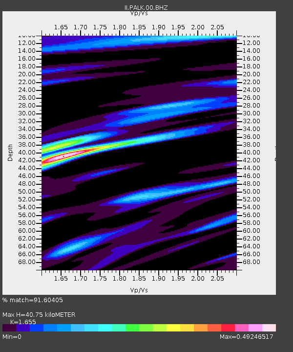
PALK Pallekele, Sri Lanka - Earthquake Result Viewer
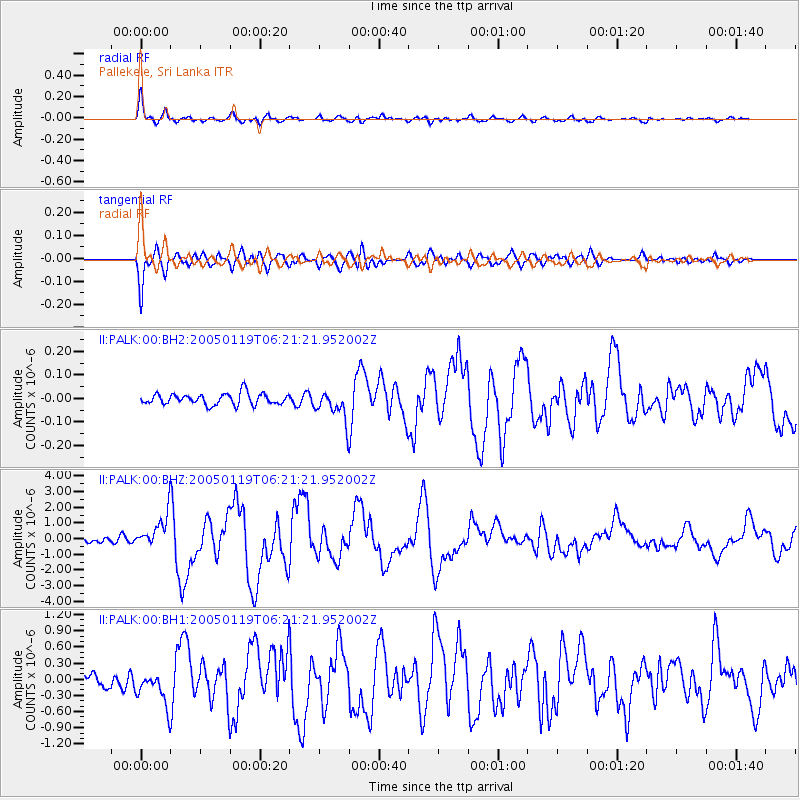
Earthquake location: Off East Coast Of Honshu, Japan
Earthquake latitude/longitude: 34.1/141.5
Earthquake time(UTC): 2005/01/19 (019) 06:11:36 GMT
Earthquake Depth: 28 km
Earthquake Magnitude: 5.8 MB, 6.4 MS, 6.5 MW, 6.4 MW
Earthquake Catalog/Contributor: WHDF/NEIC
Network: II Global Seismograph Network (GSN - IRIS/IDA)
Station: PALK Pallekele, Sri Lanka
Lat/Lon: 7.27 N/80.70 E
Elevation: 460 m
Distance: 61.8 deg
Az: 259.177 deg
Baz: 55.277 deg
Ray Param: 0.06058197
Estimated Moho Depth: 40.75 km
Estimated Crust Vp/Vs: 1.65
Assumed Crust Vp: 6.545 km/s
Estimated Crust Vs: 3.955 km/s
Estimated Crust Poisson's Ratio: 0.21
Radial Match: 91.60405 %
Radial Bump: 400
Transverse Match: 88.59008 %
Transverse Bump: 400
SOD ConfigId: 590571
Insert Time: 2013-09-25 09:42:41.061 +0000
GWidth: 2.5
Max Bumps: 400
Tol: 0.001

Signal To Noise

ChannelStoNSTALTA
II:PALK:00:BHZ:20050119T06:21:21.952002Z6.3682591.051127E-61.650572E-7
II:PALK:00:BH1:20050119T06:21:21.952002Z1.87110783.0857484E-71.6491558E-7
II:PALK:00:BH2:20050119T06:21:21.952002Z2.58516766.165599E-82.38499E-8
Arrivals
Ps4.3 SECOND
PpPs16 SECOND
PsPs/PpSs20 SECOND