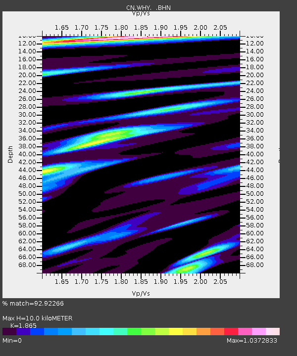
WHY Whitehorse, YT - Earthquake Result Viewer

Earthquake location: Minahassa Peninsula, Sulawesi
Earthquake latitude/longitude: 1.3/122.1
Earthquake time(UTC): 2008/11/16 (321) 17:02:32 GMT
Earthquake Depth: 30 km
Earthquake Magnitude: 6.5 MB, 7.0 MS, 7.3 MW, 7.3 MW
Earthquake Catalog/Contributor: WHDF/NEIC
Network: CN Canadian National Seismograph Network
Station: WHY Whitehorse, YT
Lat/Lon: 60.66 N/134.88 W
Elevation: 1292 m
Distance: 95.3 deg
Az: 28.807 deg
Baz: 281.998 deg
Ray Param: 0.040814873
Estimated Moho Depth: 10.0 km
Estimated Crust Vp/Vs: 1.87
Assumed Crust Vp: 6.419 km/s
Estimated Crust Vs: 3.442 km/s
Estimated Crust Poisson's Ratio: 0.30
Radial Match: 92.92266 %
Radial Bump: 396
Transverse Match: 77.89454 %
Transverse Bump: 400
SOD ConfigId: 2658
Insert Time: 2010-02-27 07:54:39.069 +0000
GWidth: 2.5
Max Bumps: 400
Tol: 0.001

Signal To Noise

ChannelStoNSTALTA
CN:WHY: :BHN:20081116T17:15:22.100024Z3.58734873.9175038E-71.0920332E-7
CN:WHY: :BHE:20081116T17:15:22.100024Z0.76734311.0991346E-71.4323899E-7
CN:WHY: :BHZ:20081116T17:15:22.100024Z1.07621931.4519685E-71.349138E-7
Arrivals
Ps1.4 SECOND
PpPs4.4 SECOND
PsPs/PpSs5.8 SECOND