You are here: Home > Network List > CN - Canadian National Seismograph Network Stations List
> Station WHY Whitehorse, YT > Earthquake Result Viewer
WHY Whitehorse, YT - Earthquake Result Viewer

| Earthquake location: |
Gulf Of California |
| Earthquake latitude/longitude: |
29.0/-112.9 |
| Earthquake time(UTC): |
2009/08/03 (215) 17:59:56 GMT |
| Earthquake Depth: |
10 km |
| Earthquake Magnitude: |
6.2 MB, 6.9 MW, 6.8 MW |
| Earthquake Catalog/Contributor: |
WHDF/NEIC |
|
| Network: |
CN Canadian National Seismograph Network |
| Station: |
WHY Whitehorse, YT |
| Lat/Lon: |
60.66 N/134.88 W |
| Elevation: |
1292 m |
|
| Distance: |
34.9 deg |
| Az: |
341.204 deg |
| Baz: |
145.05 deg |
| Ray Param: |
0.07750595 |
| Estimated Moho Depth: |
51.25 km |
| Estimated Crust Vp/Vs: |
1.60 |
| Assumed Crust Vp: |
6.419 km/s |
| Estimated Crust Vs: |
4.012 km/s |
| Estimated Crust Poisson's Ratio: |
0.18 |
|
| Radial Match: |
93.41056 % |
| Radial Bump: |
277 |
| Transverse Match: |
76.983986 % |
| Transverse Bump: |
400 |
| SOD ConfigId: |
2622 |
| Insert Time: |
2010-02-27 07:54:46.069 +0000 |
| GWidth: |
2.5 |
| Max Bumps: |
400 |
| Tol: |
0.001 |
|
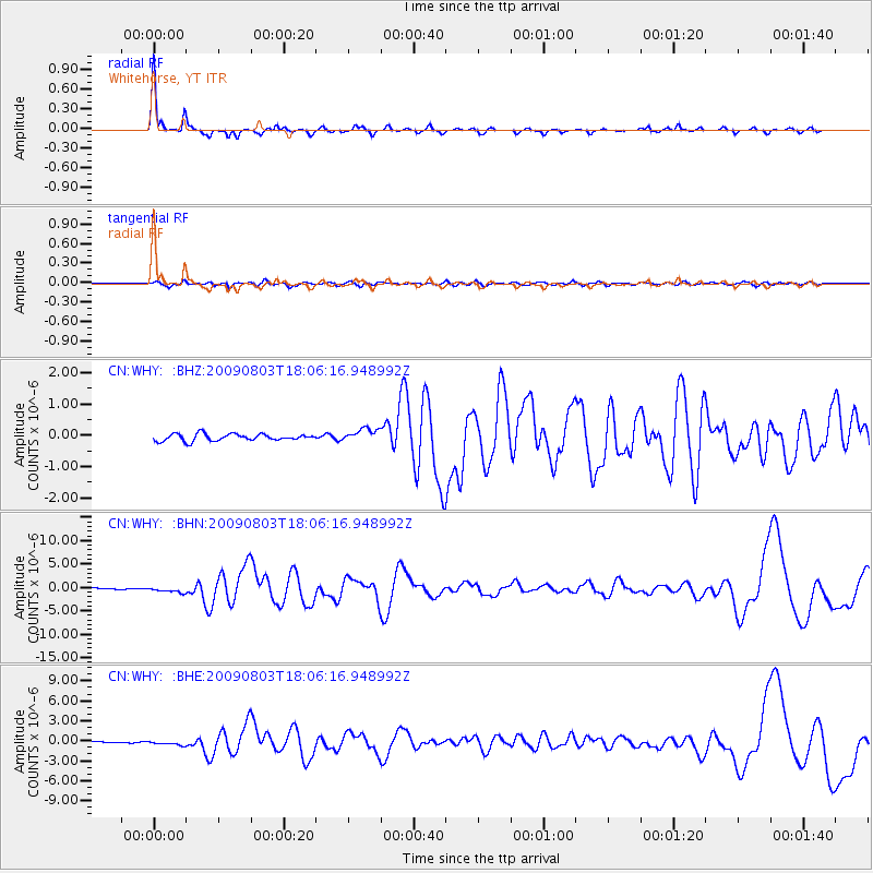
Signal To Noise
| Channel | StoN | STA | LTA |
| CN:WHY: :BHN:20090803T18:06:16.948992Z | 5.5474496 | 5.952415E-7 | 1.07300025E-7 |
| CN:WHY: :BHE:20090803T18:06:16.948992Z | 2.8990545 | 3.1593078E-7 | 1.0897718E-7 |
| CN:WHY: :BHZ:20090803T18:06:16.948992Z | 1.8974662 | 2.0958379E-7 | 1.1045456E-7 |
| Arrivals |
| Ps | 5.2 SECOND |
| PpPs | 19 SECOND |
| PsPs/PpSs | 24 SECOND |


