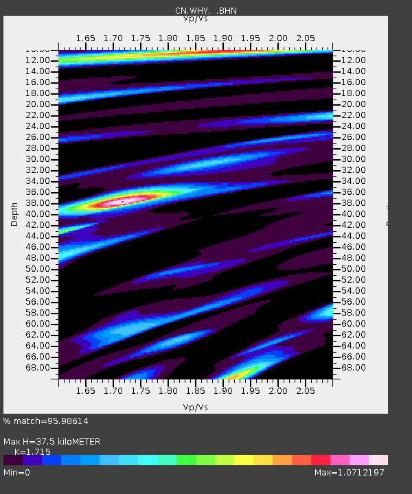
WHY Whitehorse, YT - Earthquake Result Viewer

Earthquake location: Southwestern Ryukyu Isl., Japan
Earthquake latitude/longitude: 23.5/123.5
Earthquake time(UTC): 2009/08/17 (229) 00:05:49 GMT
Earthquake Depth: 20 km
Earthquake Magnitude: 6.2 MB, 6.6 MS, 6.7 MW, 6.6 MW
Earthquake Catalog/Contributor: WHDF/NEIC
Network: CN Canadian National Seismograph Network
Station: WHY Whitehorse, YT
Lat/Lon: 60.66 N/134.88 W
Elevation: 1292 m
Distance: 75.3 deg
Az: 29.918 deg
Baz: 291.611 deg
Ray Param: 0.051753826
Estimated Moho Depth: 37.5 km
Estimated Crust Vp/Vs: 1.72
Assumed Crust Vp: 6.419 km/s
Estimated Crust Vs: 3.743 km/s
Estimated Crust Poisson's Ratio: 0.24
Radial Match: 95.98614 %
Radial Bump: 400
Transverse Match: 88.26452 %
Transverse Bump: 400
SOD ConfigId: 2622
Insert Time: 2010-02-27 07:55:04.746 +0000
GWidth: 2.5
Max Bumps: 400
Tol: 0.001

Signal To Noise

ChannelStoNSTALTA
CN:WHY: :BHN:20090817T00:16:59.30002Z9.4506191.1406335E-61.2069405E-7
CN:WHY: :BHE:20090817T00:16:59.30002Z3.03069143.1764128E-71.0480819E-7
CN:WHY: :BHZ:20090817T00:16:59.30002Z4.26346833.650818E-78.563024E-8
Arrivals
Ps4.3 SECOND
PpPs15 SECOND
PsPs/PpSs20 SECOND