You are here: Home > Network List > CN - Canadian National Seismograph Network Stations List
> Station WHY Whitehorse, YT > Earthquake Result Viewer
WHY Whitehorse, YT - Earthquake Result Viewer

| Earthquake location: |
North Of Honduras |
| Earthquake latitude/longitude: |
16.7/-86.2 |
| Earthquake time(UTC): |
2009/05/28 (148) 08:24:45 GMT |
| Earthquake Depth: |
10 km |
| Earthquake Magnitude: |
6.7 MB, 7.2 MS, 7.3 MW, 7.3 MW |
| Earthquake Catalog/Contributor: |
WHDF/NEIC |
|
| Network: |
CN Canadian National Seismograph Network |
| Station: |
WHY Whitehorse, YT |
| Lat/Lon: |
60.66 N/134.88 W |
| Elevation: |
1292 m |
|
| Distance: |
55.9 deg |
| Az: |
333.483 deg |
| Baz: |
119.693 deg |
| Ray Param: |
0.06449283 |
| Estimated Moho Depth: |
34.5 km |
| Estimated Crust Vp/Vs: |
1.86 |
| Assumed Crust Vp: |
6.419 km/s |
| Estimated Crust Vs: |
3.451 km/s |
| Estimated Crust Poisson's Ratio: |
0.30 |
|
| Radial Match: |
94.76977 % |
| Radial Bump: |
400 |
| Transverse Match: |
89.830986 % |
| Transverse Bump: |
400 |
| SOD ConfigId: |
2648 |
| Insert Time: |
2010-02-27 07:55:54.413 +0000 |
| GWidth: |
2.5 |
| Max Bumps: |
400 |
| Tol: |
0.001 |
|
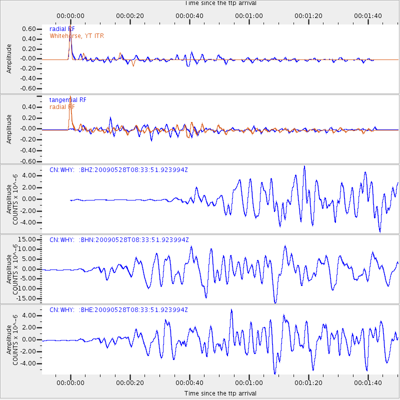
Signal To Noise
| Channel | StoN | STA | LTA |
| CN:WHY: :BHN:20090528T08:33:51.923994Z | 5.3695536 | 3.2652744E-7 | 6.0810905E-8 |
| CN:WHY: :BHE:20090528T08:33:51.923994Z | 1.7818652 | 1.072316E-7 | 6.017941E-8 |
| CN:WHY: :BHZ:20090528T08:33:51.923994Z | 2.8292923 | 1.4462346E-7 | 5.1116476E-8 |
| Arrivals |
| Ps | 4.9 SECOND |
| PpPs | 15 SECOND |
| PsPs/PpSs | 19 SECOND |


