You are here: Home > Network List > II - Global Seismograph Network (GSN - IRIS/IDA) Stations List
> Station MSEY Mahe, Seychelles > Earthquake Result Viewer
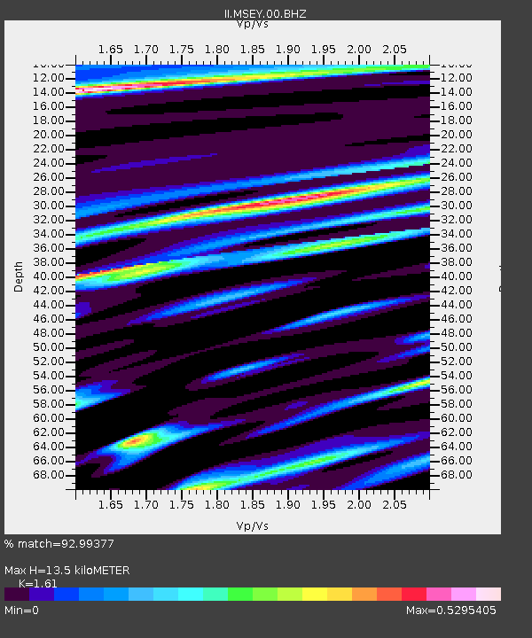
MSEY Mahe, Seychelles - Earthquake Result Viewer
| Earthquake location: |
Mindanao, Philippines |
| Earthquake latitude/longitude: |
5.3/123.3 |
| Earthquake time(UTC): |
2005/02/05 (036) 12:23:18 GMT |
| Earthquake Depth: |
525 km |
| Earthquake Magnitude: |
6.4 MB, 7.1 MW, 7.1 MW |
| Earthquake Catalog/Contributor: |
WHDF/NEIC |
|
| Network: |
II Global Seismograph Network (GSN - IRIS/IDA) |
| Station: |
MSEY Mahe, Seychelles |
| Lat/Lon: |
4.67 S/55.48 E |
| Elevation: |
475 m |
|
| Distance: |
68.5 deg |
| Az: |
262.898 deg |
| Baz: |
82.483 deg |
| Ray Param: |
0.054468717 |
| Estimated Moho Depth: |
13.5 km |
| Estimated Crust Vp/Vs: |
1.61 |
| Assumed Crust Vp: |
6.303 km/s |
| Estimated Crust Vs: |
3.915 km/s |
| Estimated Crust Poisson's Ratio: |
0.19 |
|
| Radial Match: |
92.99377 % |
| Radial Bump: |
400 |
| Transverse Match: |
82.23597 % |
| Transverse Bump: |
400 |
| SOD ConfigId: |
590571 |
| Insert Time: |
2013-09-25 10:27:51.209 +0000 |
| GWidth: |
2.5 |
| Max Bumps: |
400 |
| Tol: |
0.001 |
|

Signal To Noise
| Channel | StoN | STA | LTA |
| II:MSEY:00:BHZ:20050205T12:32:57.572019Z | 16.596958 | 3.6764889E-6 | 2.2151583E-7 |
| II:MSEY:00:BH1:20050205T12:32:57.572019Z | 5.4602995 | 1.3063523E-6 | 2.392455E-7 |
| II:MSEY:00:BH2:20050205T12:32:57.572019Z | 1.5316622 | 3.703636E-7 | 2.4180503E-7 |
| Arrivals |
| Ps | 1.4 SECOND |
| PpPs | 5.4 SECOND |
| PsPs/PpSs | 6.7 SECOND |


