You are here: Home > Network List > II - Global Seismograph Network (GSN - IRIS/IDA) Stations List
> Station PALK Pallekele, Sri Lanka > Earthquake Result Viewer
PALK Pallekele, Sri Lanka - Earthquake Result Viewer
| Earthquake location: |
Mindanao, Philippines |
| Earthquake latitude/longitude: |
5.3/123.3 |
| Earthquake time(UTC): |
2005/02/05 (036) 12:23:18 GMT |
| Earthquake Depth: |
525 km |
| Earthquake Magnitude: |
6.4 MB, 7.1 MW, 7.1 MW |
| Earthquake Catalog/Contributor: |
WHDF/NEIC |
|
| Network: |
II Global Seismograph Network (GSN - IRIS/IDA) |
| Station: |
PALK Pallekele, Sri Lanka |
| Lat/Lon: |
7.27 N/80.70 E |
| Elevation: |
460 m |
|
| Distance: |
42.4 deg |
| Az: |
274.963 deg |
| Baz: |
90.104 deg |
| Ray Param: |
0.070629485 |
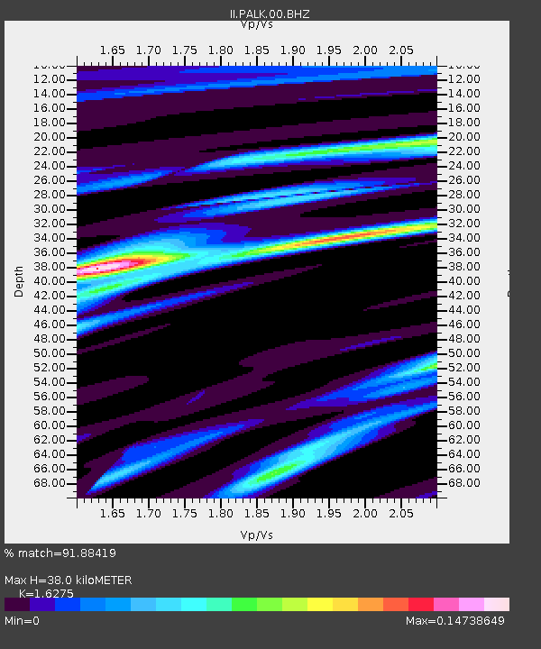
| Estimated Moho Depth: |
38.0 km |
| Estimated Crust Vp/Vs: |
1.63 |
| Assumed Crust Vp: |
6.545 km/s |
| Estimated Crust Vs: |
4.022 km/s |
| Estimated Crust Poisson's Ratio: |
0.20 |
|
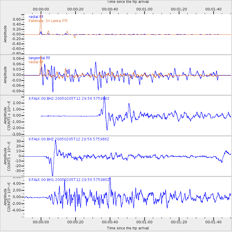
| Radial Match: |
91.88419 % |
| Radial Bump: |
258 |
| Transverse Match: |
72.08938 % |
| Transverse Bump: |
400 |
| SOD ConfigId: |
590571 |
| Insert Time: |
2013-09-25 10:27:55.908 +0000 |
| GWidth: |
2.5 |
| Max Bumps: |
400 |
| Tol: |
0.001 |
|
Signal To Noise
| Channel | StoN | STA | LTA |
| II:PALK:00:BHZ:20050205T12:29:56.575986Z | 17.41797 | 2.3301595E-6 | 1.3377904E-7 |
| II:PALK:00:BH1:20050205T12:29:56.575986Z | 1.8024375 | 1.432849E-7 | 7.9495074E-8 |
| II:PALK:00:BH2:20050205T12:29:56.575986Z | 12.710163 | 1.7942905E-7 | 1.4116974E-8 |
| Arrivals |
| Ps | 3.9 SECOND |
| PpPs | 14 SECOND |
| PsPs/PpSs | 18 SECOND |


