You are here: Home > Network List > TA - USArray Transportable Network (new EarthScope stations) Stations List
> Station O48A Farmland, IN, USA > Earthquake Result Viewer
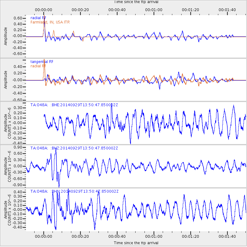
O48A Farmland, IN, USA - Earthquake Result Viewer
*The percent match for this event was below the threshold and hence no stack was calculated.
| Earthquake location: |
Iceland |
| Earthquake latitude/longitude: |
64.5/-17.3 |
| Earthquake time(UTC): |
2014/09/29 (272) 13:43:01 GMT |
| Earthquake Depth: |
10 km |
| Earthquake Magnitude: |
5.6 MWW, 5.5 MWC |
| Earthquake Catalog/Contributor: |
NEIC PDE/NEIC COMCAT |
|
| Network: |
TA USArray Transportable Network (new EarthScope stations) |
| Station: |
O48A Farmland, IN, USA |
| Lat/Lon: |
40.26 N/85.16 W |
| Elevation: |
300 m |
|
| Distance: |
45.2 deg |
| Az: |
271.481 deg |
| Baz: |
34.422 deg |
| Ray Param: |
$rayparam |
*The percent match for this event was below the threshold and hence was not used in the summary stack. |
|
| Radial Match: |
71.69132 % |
| Radial Bump: |
400 |
| Transverse Match: |
53.527 % |
| Transverse Bump: |
365 |
| SOD ConfigId: |
3390531 |
| Insert Time: |
2019-04-14 06:33:24.459 +0000 |
| GWidth: |
2.5 |
| Max Bumps: |
400 |
| Tol: |
0.001 |
|
Signal To Noise
| Channel | StoN | STA | LTA |
| TA:O48A: :BHZ:20140929T13:50:47.850002Z | 2.6323466 | 2.8492042E-7 | 1.0823818E-7 |
| TA:O48A: :BHN:20140929T13:50:47.850002Z | 2.0013645 | 1.8589509E-7 | 9.288418E-8 |
| TA:O48A: :BHE:20140929T13:50:47.850002Z | 1.1531506 | 1.175443E-7 | 1.0193318E-7 |
| Arrivals |
| Ps | |
| PpPs | |
| PsPs/PpSs | |


