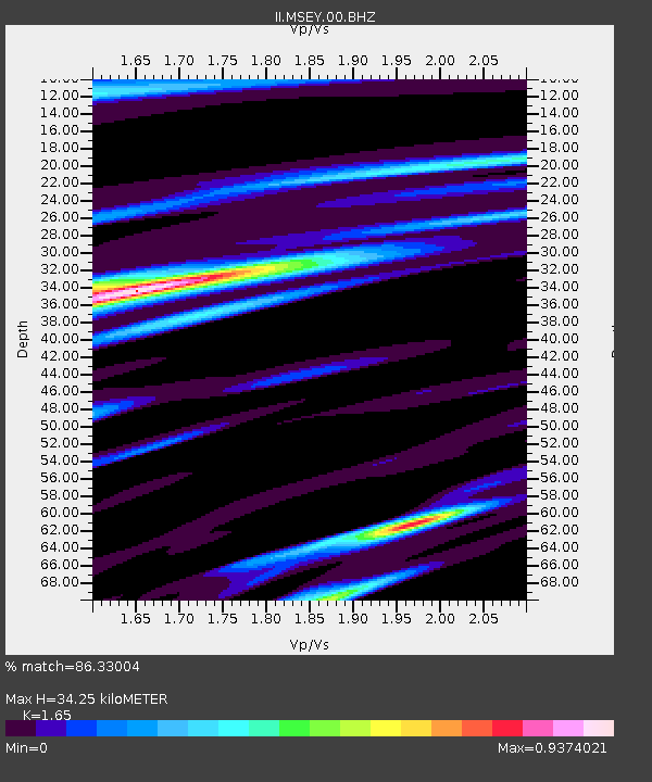
MSEY Mahe, Seychelles - Earthquake Result Viewer
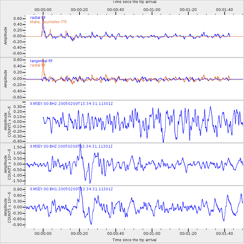
Earthquake location: Northern Sumatra, Indonesia
Earthquake latitude/longitude: 4.8/95.1
Earthquake time(UTC): 2005/02/09 (040) 13:27:25 GMT
Earthquake Depth: 44 km
Earthquake Magnitude: 5.7 MB, 5.5 MS, 6.0 MW, 6.0 MW
Earthquake Catalog/Contributor: WHDF/NEIC
Network: II Global Seismograph Network (GSN - IRIS/IDA)
Station: MSEY Mahe, Seychelles
Lat/Lon: 4.67 S/55.48 E
Elevation: 475 m
Distance: 40.7 deg
Az: 257.203 deg
Baz: 77.159 deg
Ray Param: 0.07414004
Estimated Moho Depth: 34.25 km
Estimated Crust Vp/Vs: 1.65
Assumed Crust Vp: 6.303 km/s
Estimated Crust Vs: 3.82 km/s
Estimated Crust Poisson's Ratio: 0.21
Radial Match: 86.33004 %
Radial Bump: 400
Transverse Match: 72.557465 %
Transverse Bump: 400
SOD ConfigId: 590571
Insert Time: 2013-09-25 10:33:44.576 +0000
GWidth: 2.5
Max Bumps: 400
Tol: 0.001

Signal To Noise

ChannelStoNSTALTA
II:MSEY:00:BHZ:20050209T13:34:31.11301Z3.07079342.9535286E-79.618128E-8
II:MSEY:00:BH1:20050209T13:34:31.11301Z2.7634291.9898943E-77.2008156E-8
II:MSEY:00:BH2:20050209T13:34:31.11301Z0.89494358.326924E-89.3044136E-8
Arrivals
Ps3.8 SECOND
PpPs13 SECOND
PsPs/PpSs17 SECOND