You are here: Home > Network List > CN - Canadian National Seismograph Network Stations List
> Station WHY Whitehorse, YT > Earthquake Result Viewer
WHY Whitehorse, YT - Earthquake Result Viewer

| Earthquake location: |
Taiwan Region |
| Earthquake latitude/longitude: |
21.3/122.0 |
| Earthquake time(UTC): |
1998/07/24 (205) 18:44:04 GMT |
| Earthquake Depth: |
33 km |
| Earthquake Magnitude: |
5.6 MB, 5.9 MS, 6.2 UNKNOWN, 6.1 MW |
| Earthquake Catalog/Contributor: |
WHDF/NEIC |
|
| Network: |
CN Canadian National Seismograph Network |
| Station: |
WHY Whitehorse, YT |
| Lat/Lon: |
60.66 N/134.88 W |
| Elevation: |
1292 m |
|
| Distance: |
77.9 deg |
| Az: |
29.378 deg |
| Baz: |
291.698 deg |
| Ray Param: |
0.049958088 |
| Estimated Moho Depth: |
10.75 km |
| Estimated Crust Vp/Vs: |
1.73 |
| Assumed Crust Vp: |
6.419 km/s |
| Estimated Crust Vs: |
3.711 km/s |
| Estimated Crust Poisson's Ratio: |
0.25 |
|
| Radial Match: |
95.33838 % |
| Radial Bump: |
361 |
| Transverse Match: |
83.06349 % |
| Transverse Bump: |
400 |
| SOD ConfigId: |
4480 |
| Insert Time: |
2010-02-27 07:56:17.620 +0000 |
| GWidth: |
2.5 |
| Max Bumps: |
400 |
| Tol: |
0.001 |
|
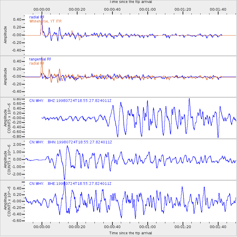
Signal To Noise
| Channel | StoN | STA | LTA |
| CN:WHY: :BHN:19980724T18:55:27.824011Z | 3.4520104 | 2.278085E-7 | 6.599299E-8 |
| CN:WHY: :BHE:19980724T18:55:27.824011Z | 1.5506952 | 9.535235E-8 | 6.149007E-8 |
| CN:WHY: :BHZ:19980724T18:55:27.824011Z | 1.6813393 | 8.739081E-8 | 5.1976905E-8 |
| Arrivals |
| Ps | 1.3 SECOND |
| PpPs | 4.4 SECOND |
| PsPs/PpSs | 5.7 SECOND |


