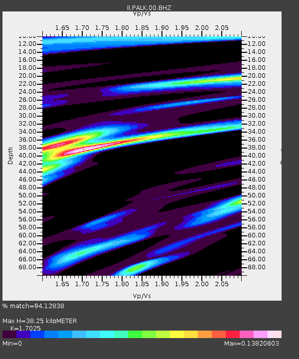
PALK Pallekele, Sri Lanka - Earthquake Result Viewer
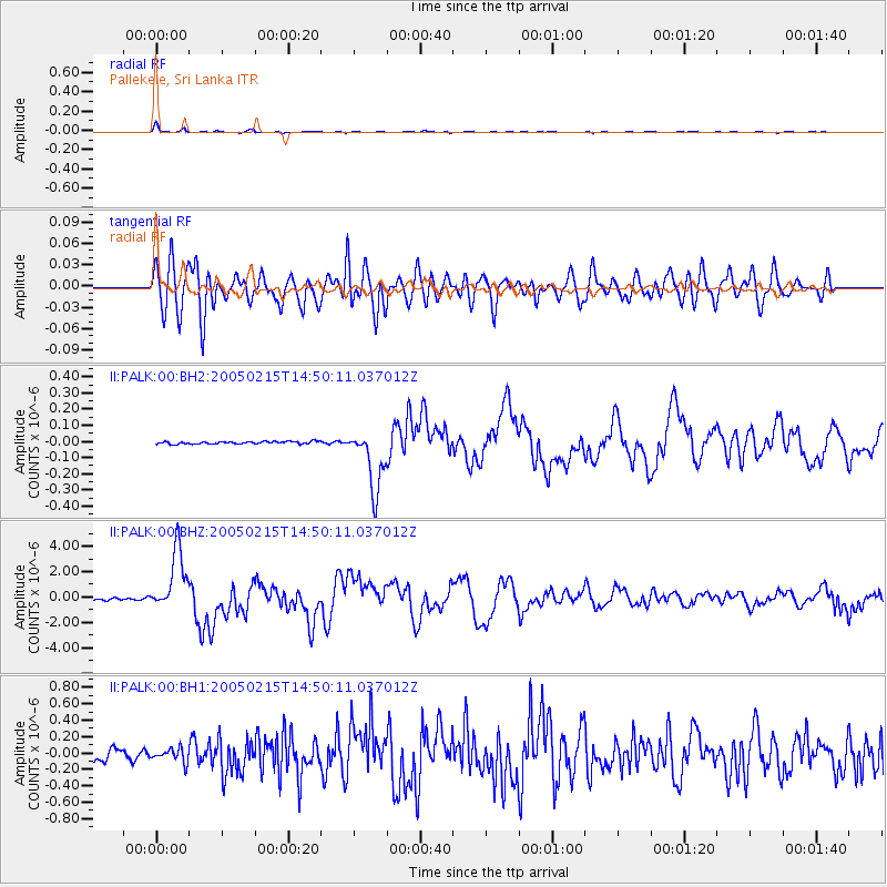
Earthquake location: Talaud Islands, Indonesia
Earthquake latitude/longitude: 4.8/126.4
Earthquake time(UTC): 2005/02/15 (046) 14:42:25 GMT
Earthquake Depth: 40 km
Earthquake Magnitude: 6.1 MB, 6.0 MS, 6.6 MW, 6.4 MW
Earthquake Catalog/Contributor: WHDF/NEIC
Network: II Global Seismograph Network (GSN - IRIS/IDA)
Station: PALK Pallekele, Sri Lanka
Lat/Lon: 7.27 N/80.70 E
Elevation: 460 m
Distance: 45.5 deg
Az: 275.492 deg
Baz: 90.466 deg
Ray Param: 0.07112938
Estimated Moho Depth: 38.25 km
Estimated Crust Vp/Vs: 1.70
Assumed Crust Vp: 6.545 km/s
Estimated Crust Vs: 3.845 km/s
Estimated Crust Poisson's Ratio: 0.24
Radial Match: 94.12838 %
Radial Bump: 357
Transverse Match: 77.917946 %
Transverse Bump: 400
SOD ConfigId: 590571
Insert Time: 2013-09-25 10:43:52.679 +0000
GWidth: 2.5
Max Bumps: 400
Tol: 0.001

Signal To Noise

ChannelStoNSTALTA
II:PALK:00:BHZ:20050215T14:50:11.037012Z30.5549772.3945904E-67.8369894E-8
II:PALK:00:BH1:20050215T14:50:11.037012Z1.57511588.3816225E-85.321274E-8
II:PALK:00:BH2:20050215T14:50:11.037012Z24.9493181.9036483E-77.630062E-9
Arrivals
Ps4.4 SECOND
PpPs15 SECOND
PsPs/PpSs19 SECOND