MBAR Mbarara, Uganda - Earthquake Result Viewer
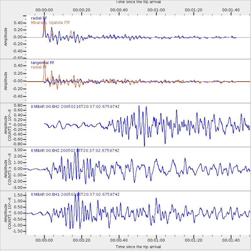
Earthquake location: Southern Mid-Atlantic Ridge
Earthquake latitude/longitude: -36.3/-16.6
Earthquake time(UTC): 2005/02/16 (047) 20:27:52 GMT
Earthquake Depth: 10 km
Earthquake Magnitude: 6.0 MB, 6.1 MS, 6.6 MW, 6.5 MW
Earthquake Catalog/Contributor: WHDF/NEIC
Network: II Global Seismograph Network (GSN - IRIS/IDA)
Station: MBAR Mbarara, Uganda
Lat/Lon: 0.60 S/30.74 E
Elevation: 1390 m
Distance: 56.4 deg
Az: 61.952 deg
Baz: 225.464 deg
Ray Param: 0.06418747
Estimated Moho Depth: 12.5 km
Estimated Crust Vp/Vs: 1.89
Assumed Crust Vp: 6.419 km/s
Estimated Crust Vs: 3.387 km/s
Estimated Crust Poisson's Ratio: 0.31
Radial Match: 93.40901 %
Radial Bump: 390
Transverse Match: 85.15685 %
Transverse Bump: 400
SOD ConfigId: 590571
Insert Time: 2013-09-25 10:46:20.688 +0000
GWidth: 2.5
Max Bumps: 400
Tol: 0.001

Signal To Noise

ChannelStoNSTALTA
II:MBAR:00:BHZ:20050216T20:37:02.675974Z6.92834425.37397E-77.756499E-8
II:MBAR:00:BH1:20050216T20:37:02.675974Z5.3405542.2635533E-74.2384237E-8
II:MBAR:00:BH2:20050216T20:37:02.675974Z1.275259.018394E-87.071864E-8
Arrivals
Ps1.8 SECOND
PpPs5.4 SECOND
PsPs/PpSs7.2 SECOND